<?xml version='1.0' encoding='UTF-8'?>

<!DOCTYPE article PUBLIC "-//NLM//DTD JATS (Z39.96) Journal Publishing DTD v1.1d1 20130915//EN" "JATS-journalpublishing1.dtd">
<article xmlns:xlink="http://www.w3.org/1999/xlink">
  <front>
    <journal-meta id="journal-meta-87cddb9ab7774ac9973b6a64b7cbc767">
      <journal-id journal-id-type="nlm-ta">Sciresol</journal-id>
      <journal-id journal-id-type="publisher-id">Sciresol</journal-id>
      <journal-id journal-id-type="journal_submission_guidelines">https://jmsh.ac.in/</journal-id>
      <journal-title-group>
        <journal-title>Journal of Medical Sciences and Health</journal-title>
      </journal-title-group>
      <issn publication-format="print"/>
    </journal-meta>
    <article-meta>
        
          
            <article-id pub-id-type="doi">10.53989/bu.ge.v15.i1.krishna</article-id>
          
          
            <article-categories>
              <subj-group>
                <subject>ORIGINAL ARTICLE</subject>
              </subj-group>
            </article-categories>
            <title-group>
              <article-title>Spatio-Temporal Dynamics and Future Projection of Land Use/Land Cover in the Shivamogga-Bhadravati Local Planning Area, Karnataka, India (1995-2035)</article-title>
            </title-group>
          
          
            <pub-date date-type="pub">
              <day>30</day>
              <month>3</month>
              <year>2026</year>
            </pub-date>
            <permissions>
              <copyright-year>2026</copyright-year>
            </permissions>
          
          
            <volume>15</volume>
          
          
            <issue>1</issue>
          
          <fpage>1</fpage>

          <abstract>
            <title>Abstract</title>
            &lt;p&gt;Rapid land use/land cover (LULC) change associated with urban and regional development requires systematic assessment to support sustainable planning. This study examines the spatio-temporal dynamics of LULC in the Shivamogga-Bhadravati Local Planning Area (LPA), Karnataka, India, from 1995 to 2025 and projects the potential LULC scenario for 2035. Multi-temporal satellite imagery for 1995, 2005, 2015 and 2025 was classified using supervised classification in QGIS into five LULC classes: agriculture, built-up, waterbody, vegetation and barren land. LULC changes were quantified using area statistics, net change and percentage change, while the 2035 scenario was projected using the CA-based SLEUTH model. Built-up land increased from 31.88 km² in 1995 to 103.56 km² in 2025, representing a net increase of 71.68 km² (224.8%), while agricultural land increased by 43.65 km² (37.4%). In contrast, barren land declined by 111.66 km² (78.1%), whereas vegetation and waterbody areas showed relatively limited changes. The 2035 projection indicates a further increase in built-up land to 123.73 km², accompanied by declines in agricultural land to 149.95 km² and barren land to 23.14 km². The findings indicate continued landscape transformation and increasing development pressure within the LPA. The study highlights the value of integrating multi-temporal remote sensing analysis with future land-use projection to provide a spatially informed basis for sustainable and effective local planning.&lt;/p&gt;
          </abstract>
          
          
            <kwd-group>
              <title>Keywords</title>
              
                <kwd>Land use/land cover; Spatio-temporal dynamics; Remote sensing; GIS; Urban expansion; Local planning area; Shivamogga-Bhadravati</kwd>
              
            </kwd-group>


        <contrib-group>
          
            
              <contrib contrib-type="author">
                <name>
                  <surname>Krishnaswamy</surname>
                  <given-names>H P</given-names>
                </name>
                
                  <xref rid="aff-1" ref-type="aff">1</xref>
                
              </contrib>


              <aff id="aff-1">
                <institution>Research Scholar Department of Geography Karnataka State Open University </institution>
                <addr-line>Mysuru-06, Karnataka India</addr-line>
              </aff>
            
              <aff id="aff-2">
                <institution>Assistant Professor Department of Geography Karnataka State Open University </institution>
                <addr-line>Mysuru-06, Karnataka India</addr-line>
              </aff>


              <contrib contrib-type="author">
                <name>
                  <surname>Manjunatha</surname>
                  <given-names>C S</given-names>
                </name>
                
                  <xref rid="aff-2" ref-type="aff">2</xref>
                
              </contrib>


              <aff id="aff-1">
                <institution>Research Scholar Department of Geography Karnataka State Open University </institution>
                <addr-line>Mysuru-06, Karnataka India</addr-line>
              </aff>
            
              <aff id="aff-2">
                <institution>Assistant Professor Department of Geography Karnataka State Open University </institution>
                <addr-line>Mysuru-06, Karnataka India</addr-line>
              </aff>
            
          
        </contrib-group>
        
    </article-meta>
  </front>
  <body>
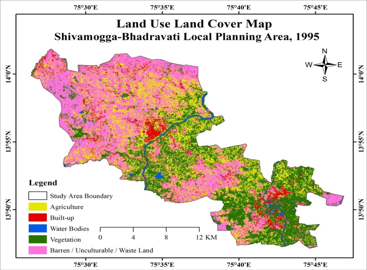
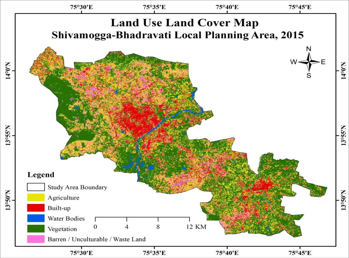
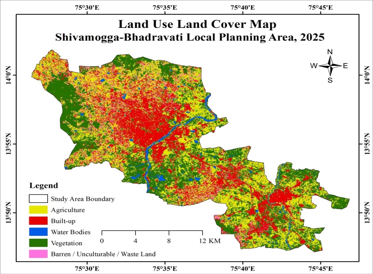
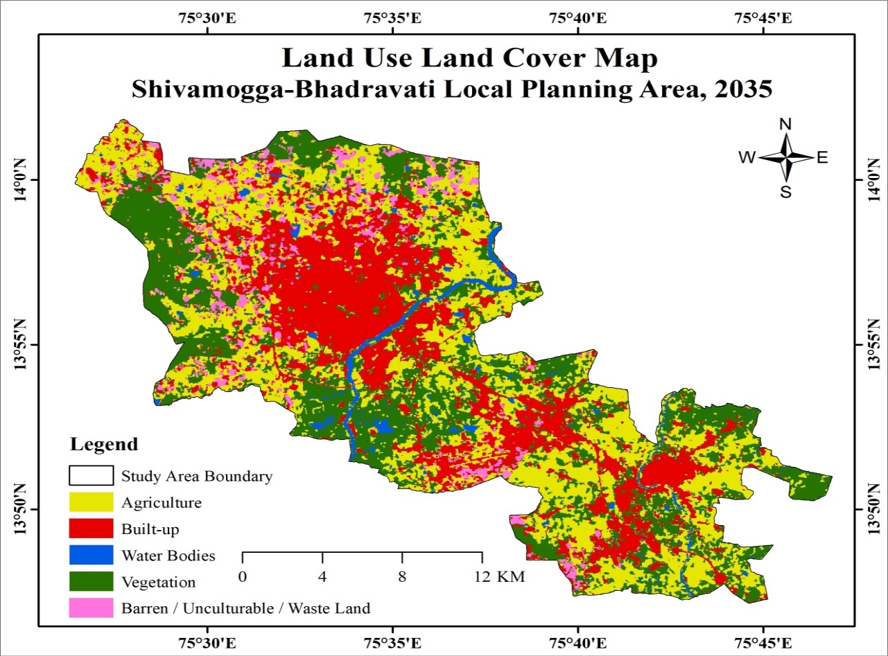
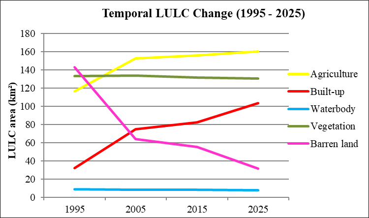
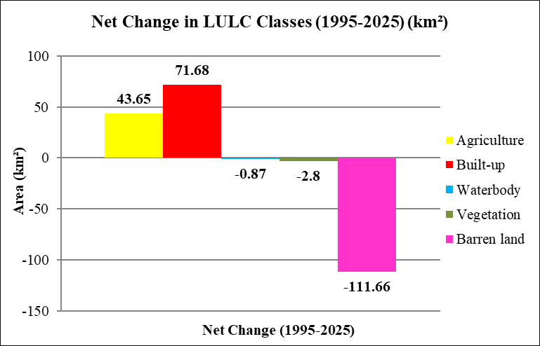
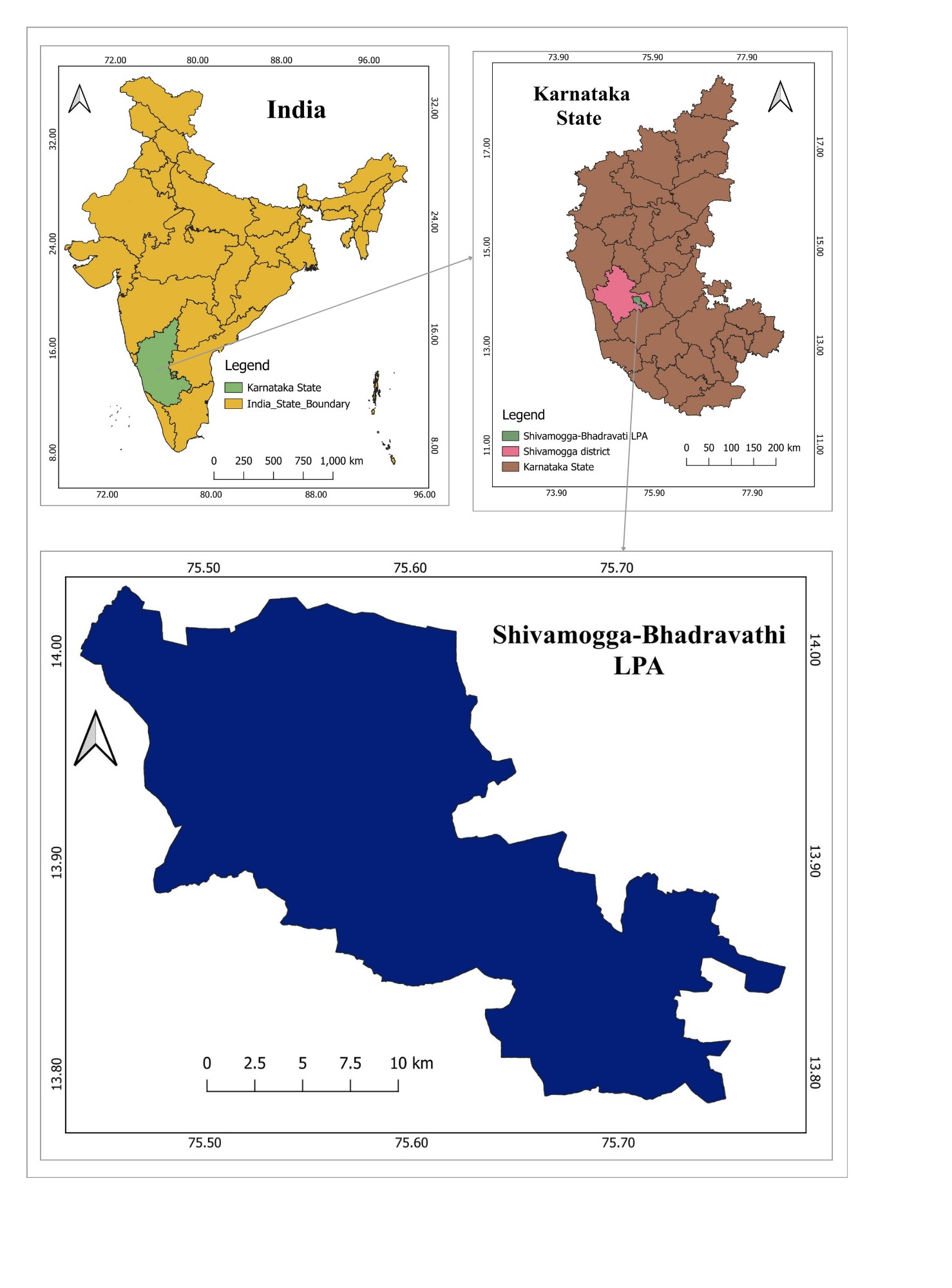
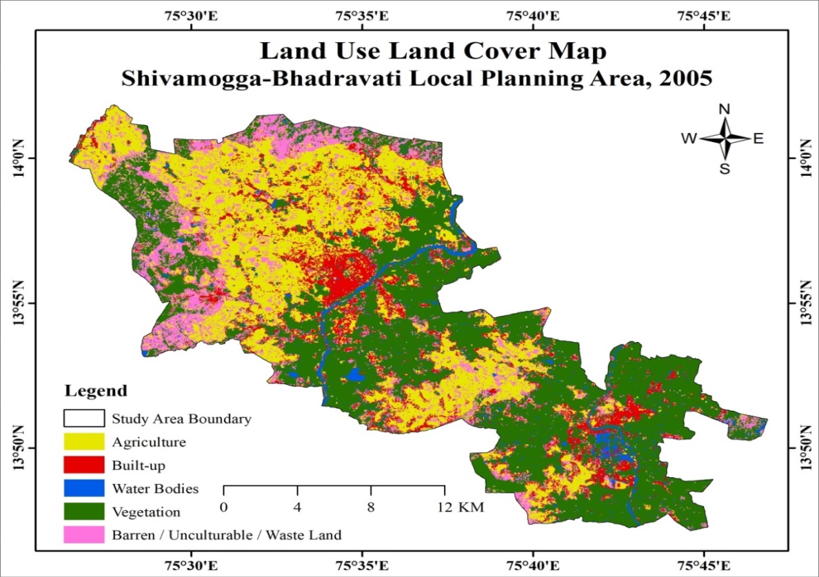
    <heading><span><bold>1 Introduction</bold></span></heading><p><span>Land use/land cover (LULC) is an important indicator of landscape and regional transformation, reflecting the interacting influences of environmental, demographic and socio-economic processes on human-environment systems <superscript>[<xref ref-type="link" rid="#ref-1">1</xref>]</superscript>. Rapid urbanisation, infrastructure development and changing land-use practices continuously modify the spatial distribution of built-up areas, agriculture, vegetation, waterbodies and barren land, making the assessment of LULC dynamics important for understanding landscape transformation and supporting sustainable land-use planning. Remote sensing and Geographic Information System (GIS) techniques provide effective means for mapping, monitoring and analysing LULC changes across different spatial and temporal scales <superscript>[<xref ref-type="link" rid="#ref-2">2</xref>-<xref ref-type="link" rid="#ref-4">4</xref>]</superscript> </span></p><p><span>Multi-temporal LULC assessment has been widely applied to examine urban expansion and associated changes in surrounding rural and agricultural landscapes. Studies have demonstrated the usefulness of geospatial techniques for analysing urban growth, sprawl and land transformation <superscript>[<xref ref-type="link" rid="#ref-5">5</xref>]</superscript>, with recent applications in Bengaluru Rural <superscript>[<xref ref-type="link" rid="#ref-6">6</xref>]</superscript>, Mysore taluk <superscript>[<xref ref-type="link" rid="#ref-7">7</xref>]</superscript>, Mysuru Local Planning District <superscript>[<xref ref-type="link" rid="#ref-8">8</xref>]</superscript>, Rewari <superscript>[<xref ref-type="link" rid="#ref-9">9</xref>]</superscript>, Sonipat-Kundli <superscript>[<xref ref-type="link" rid="#ref-10">10</xref>]</superscript> and Thoothukudi <superscript>[<xref ref-type="link" rid="#ref-11">11</xref>]</superscript>. Such studies indicate that urban expansion can substantially transform agriculture, vegetation, waterbodies and barren land, particularly in rapidly developing urban regions. The increasing availability of multi-temporal satellite data has further strengthened the scope for analysing the magnitude, direction and spatial pattern of these transformations.</span></p><p><span>Recent LULC research has also increasingly incorporated future land-use projection to move beyond retrospective assessment towards anticipating potential development pressures. Cellular-automata-based approaches, particularly the SLEUTH framework, have been widely used for simulating historical urbanisation and exploring future urban-growth scenarios <superscript>[<xref ref-type="link" rid="#ref-12">12</xref>]</superscript>. Recent applications integrating cellular automata, GIS and satellite-derived LULC data have demonstrated the potential of predictive modelling for assessing future built-up dynamics and supporting evidence-based spatial planning <superscript>[<xref ref-type="link" rid="#ref-13">13</xref>-<xref ref-type="link" rid="#ref-15">15</xref>]</superscript>.</span></p><p><span>The Shivamogga-Bhadravati Local Planning Area (LPA), encompassing Shivamogga, Bhadravati and their surrounding areas, represents an important urban-regional landscape in Karnataka where continuing urban development may influence adjoining agricultural, vegetated and other land-cover categories. Despite its planning significance, limited attention has been given to its long-term LULC transformation and potential future land-use scenario. Therefore, the present study analyses the spatio-temporal dynamics of LULC in the Shivamogga-Bhadravati LPA from 1995 to 2025 and projects the potential LULC scenario for 2035. Five major LULC classes including agriculture, built-up, waterbody, vegetation and barren land are considered to examine their spatial distribution and temporal changes. The integration of historical LULC assessment with future projection provides a forward-looking spatial perspective on potential land-use transformation and contributes to sustainable and spatially informed planning of the Shivamogga-Bhadravati LPA.</span></p><heading><span><bold>2 Study Area </bold></span></heading><p><span>The Shivamogga-Bhadravati Local Planning Area (LPA) is an important urban and regional planning area in Shivamogga district of Karnataka, encompassing the cities of Shivamogga and Bhadravati and their surrounding settlements. The LPA extends between 13.78°-14.03° N latitude and 75.44°-75.78° E longitude and covers an area of approximately 434.06 km². The region comprises urban settlements, agricultural land, vegetation and diverse rural landscapes, along with a network of rivers, streams, tanks and reservoirs. The Tunga River is the major river system flowing through Shivamogga, while the Bhadra River is an important watercourse associated with Bhadravati. Numerous tanks and smaller waterbodies are distributed across the LPA and contribute to irrigation, domestic water supply, agriculture and local ecological functions, making water resources an important component of the region’s physical landscape.</span></p><figure id="figure-1"><graphic src="https://schoproductionportal.s3.ap-south-1.amazonaws.com/data/GE/496/1790410069697.png"/><figcaption><span><bold>Fig. 1: Study Area Map - Shivamogga-Bhadravati LPA</bold></span></figcaption></figure><heading><span><bold>3 Materials and Methods</bold></span></heading><p><span>Multitemporal satellite imagery for 1995, 2005, 2015 and 2025 was used to assess LULC dynamics in the Shivamogga-Bhadravati Local Planning Area (LPA). The images were processed within the LPA boundary and classified using supervised classification in QGIS into five LULC classes: agriculture, built-up, waterbody, vegetation and barren land. Training samples were selected based on the spectral and spatial characteristics of the respective classes. Classification accuracy was assessed using reference samples, with Overall Accuracy (OA) and Kappa Coefficient (KC) used to evaluate classification reliability <xref ref-type="link" rid="#table-1">[Table. 1]</xref>.</span></p><p><span><bold>Table 1: Satellite data and accuracy assessment of LULC classification</bold></span></p><figure id="table-1"><table><thead><tr><th><p><span><bold>Year</bold></span></p></th><th><p><span><bold>Date</bold></span></p></th><th><p><span><bold>Path / Row</bold></span></p></th><th><p><span><bold>Resolution</bold></span></p></th><th><p><span><bold>Cloud cover</bold></span></p></th><th><p><span><bold>Overall Accuracy (%)</bold></span></p></th><th><p><span><bold>Kappa Coefficient</bold></span></p></th></tr></thead><tbody><tr><td><p><span>1995</span></p></td><td><p><span>15/2/1995</span></p></td><td><p><span>145/50</span></p></td><td><p><span>30 m</span></p></td><td><p><span>&lt;10%</span></p></td><td><p><span>97.26</span></p></td><td><p><span>0.96</span></p></td></tr><tr><td><p><span>2005</span></p></td><td><p><span>22/4/2005</span></p></td><td><p><span>145/50</span></p></td><td><p><span>30 m</span></p></td><td><p><span>&lt;10%</span></p></td><td><p><span>94.47</span></p></td><td><p><span>0.94</span></p></td></tr><tr><td><p><span>2015</span></p></td><td><p><span>15/5/2015</span></p></td><td><p><span>145/51</span></p></td><td><p><span>30 m</span></p></td><td><p><span>&lt;10%</span></p></td><td><p><span>89.29</span></p></td><td><p><span>0.86</span></p></td></tr><tr><td><p><span>2025</span></p></td><td><p><span>03/4/2025</span></p></td><td><p><span>145/51</span></p></td><td><p><span>30 m</span></p></td><td><p><span>&lt;10%</span></p></td><td><p><span>92.35</span></p></td><td><p><span>0.90</span></p></td></tr></tbody></table></figure><p> </p><p><span>The area of each LULC class was calculated in km², and temporal changes were evaluated using net change and percentage change.</span></p><p><span>The net change was calculated as:</span></p><p><span>Net Change = A<subscript>2025 </subscript>- A<subscript>1995</subscript></span></p><p><span>and percentage change as:</span></p><figure><graphic src="https://schoproductionportal.s3.ap-south-1.amazonaws.com/data/GE/496/1790410065661.png"/></figure><p> </p><p><span>The potential LULC scenario for 2035 was forecast using a CA-based SLEUTH model, considering the historical spatial patterns of land-use and land-cover change. Multi-temporal LULC datasets were used to calibrate the model and determine the spatial growth characteristics and transition behaviour of different LULC classes. The modelling incorporated relevant spatial input layers, including historical LULC maps, built-up and non-built-up areas, road-network data, Digital Elevation Model (DEM), slope, and existing spatial development patterns. The model considered the influence of existing land-use patterns, accessibility, topographic conditions, neighbourhood effects, and historical transition trends in allocating future LULC changes. Based on the calibrated parameters and observed historical changes, the model was used to simulate the potential spatial distribution of different LULC classes for the target year 2035.</span></p><heading><span><bold>4 Results and Discussion</bold></span></heading><p><span>The results present the spatial and temporal dynamics of LULC in the Shivamogga-Bhadravati Local Planning Area based on the classified LULC maps and area statistics. The analysis highlights the changes in major LULC classes, their temporal trends and net changes, along with the projected LULC distribution for 2035. The observed historical patterns and projected changes are discussed to understand the ongoing landscape transformation and the potential direction of future land-use change.</span></p><figure id="figure-2"><graphic src="https://schoproductionportal.s3.ap-south-1.amazonaws.com/data/GE/496/1790410066518.jpeg"/><figcaption><span><bold>Fig. 2: LULC Map of Shivamogga-Bhadravati LPA, 1995</bold></span></figcaption></figure><p><span>The LULC maps for 1995, 2005, 2015 and 2025 <xref ref-type="link" rid="#figure-2">[Fig. 2]</xref> <xref ref-type="link" rid="#figure-3">[Fig. 3]</xref><xref ref-type="link" rid="#figure-4">[Fig. 4]</xref> <xref ref-type="link" rid="#figure-5">[Fig. 5]</xref> reveal clear changes in the spatial composition of the study area. The major transformation was characterised by an expansion of agricultural and built-up land and a substantial reduction in barren land, while vegetation and waterbody areas showed comparatively limited changes. The corresponding LULC statistics and temporal trends are presented in <xref ref-type="link" rid="#table-2">[Table. 2]</xref> and <xref ref-type="link" rid="#figure-7">[Fig. 7]</xref> &amp; <xref ref-type="link" rid="#figure-8">[Fig. 8]</xref>.</span></p><p><span>Agricultural land increased from 116.86 km² in 1995 to 160.51 km² in 2025, representing a net increase of 43.65 km² (37.4%). In contrast, barren land recorded the largest absolute decline, decreasing from 142.98 km² in 1995 to 31.32 km² in 2025, a reduction of 111.66 km² (78.1%). </span></p><figure id="figure-3"><graphic src="https://schoproductionportal.s3.ap-south-1.amazonaws.com/data/GE/496/1790410066617.jpeg"/><figcaption><span><bold>Fig. 3: LULC Map of Shivamogga-Bhadravati LPA, 2005</bold></span></figcaption></figure><p> </p><figure id="figure-4"><graphic src="https://schoproductionportal.s3.ap-south-1.amazonaws.com/data/GE/496/1790410066826.jpeg"/><figcaption><span><bold>Fig. 4: LULC Map of Shivamogga-Bhadravati LPA, 2015</bold></span></figcaption></figure><figure id="figure-5"><graphic src="https://schoproductionportal.s3.ap-south-1.amazonaws.com/data/GE/496/1790410067734.jpeg"/><figcaption><span><bold>Fig. 5: LULC Map of Shivamogga-Bhadravati LPA, 2025</bold></span></figcaption></figure><figure id="figure-6"><graphic src="https://schoproductionportal.s3.ap-south-1.amazonaws.com/data/GE/496/1790410067780.jpeg"/><figcaption><span><bold>Fig. 6: Projected LULC Distribution in the Shivamogga-Bhadravati LPA, 2035</bold></span></figcaption></figure><p> </p><p><span><bold>Table 2: LULC Statistics in Shivamogga-Bhadravati LPA (1995-2025)</bold></span></p><figure id="table-2"><table><thead><tr><th><p><span><bold>LULC Class</bold></span></p></th><th><p><span><bold>1995 (km²)</bold></span></p></th><th><p><span><bold>2005 (km²)</bold></span></p></th><th><p><span><bold>2015 (km²)</bold></span></p></th><th><p><span><bold>2025 (km²)</bold></span></p></th><th><p><span><bold>Net Change (1995-2025) (km²)</bold></span></p></th><th><p><span><bold>Change (%)</bold></span></p></th></tr></thead><tbody><tr><td><p><span>Agriculture</span></p></td><td><p><span>116.86</span></p></td><td><p><span>153.13</span></p></td><td><p><span>156.35</span></p></td><td><p><span>160.51</span></p></td><td><p><span>+43.65</span></p></td><td><p><span>+37.4</span></p></td></tr><tr><td><p><span>Built-up</span></p></td><td><p><span>31.88</span></p></td><td><p><span>74.70</span></p></td><td><p><span>82.41</span></p></td><td><p><span>103.56</span></p></td><td><p><span>+71.68</span></p></td><td><p><span>+224.8</span></p></td></tr><tr><td><p><span>Waterbody</span></p></td><td><p><span>8.78</span></p></td><td><p><span>8.22</span></p></td><td><p><span>8.07</span></p></td><td><p><span>7.91</span></p></td><td><p><span>-0.87</span></p></td><td><p><span>-9.9</span></p></td></tr><tr><td><p><span>Vegetation</span></p></td><td><p><span>133.56</span></p></td><td><p><span>133.90</span></p></td><td><p><span>131.79</span></p></td><td><p><span>130.76</span></p></td><td><p><span>-2.80</span></p></td><td><p><span>-2.1</span></p></td></tr><tr><td><p><span>Barren land</span></p></td><td><p><span>142.98</span></p></td><td><p><span>64.11</span></p></td><td><p><span>55.44</span></p></td><td><p><span>31.32</span></p></td><td><p><span>-111.66</span></p></td><td><p><span>-78.1</span></p></td></tr><tr><td><p><span>Total</span></p></td><td><p><span>434.06</span></p></td><td><p><span>434.06</span></p></td><td><p><span>434.06</span></p></td><td><p><span>434.06</span></p></td><td><p><span>-</span></p></td><td><p><span>-</span></p></td></tr></tbody></table></figure><p> </p><p><span>The increase was particularly pronounced during 1995-2005, followed by more gradual growth in the subsequent periods. Built-up land exhibited the strongest relative expansion, increasing from 31.88 km² to 103.56 km², corresponding to a net increase of 71.68 km² (224.8%). The continued increase in built-up area indicates substantial expansion of developed land within the LPA over the three decades. Vegetation remained comparatively stable, with a small decline from 133.56 km² to 130.76 km² (2.1%), while waterbody area decreased from 8.78 km² to 7.91 km² (9.9%).</span></p><p> </p><p><span><bold>Table 3: Projected LULC distribution of the Shivamogga-Bhadravati LPA, 2035</bold></span></p><div><figure id="table-3"><table><thead><tr><th><p><span><bold>LULC Class</bold></span></p></th><th><p><span><bold>2025 (km²)</bold></span></p></th><th><p><span><bold>2035 Projected (km²)</bold></span></p></th><th><p><span><bold>Change 2025-2035 (km²)</bold></span></p></th></tr></thead><tbody><tr><td><p><span>Agriculture</span></p></td><td><p><span>160.51</span></p></td><td><p><span>149.95</span></p></td><td><p><span>−10.56</span></p></td></tr><tr><td><p><span>Built-up</span></p></td><td><p><span>103.56</span></p></td><td><p><span>123.73</span></p></td><td><p><span>+20.17</span></p></td></tr><tr><td><p><span>Waterbody</span></p></td><td><p><span>7.91</span></p></td><td><p><span>8.01</span></p></td><td><p><span>+0.10</span></p></td></tr><tr><td><p><span>Vegetation</span></p></td><td><p><span>130.76</span></p></td><td><p><span>129.23</span></p></td><td><p><span>−1.53</span></p></td></tr><tr><td><p><span>Barren land</span></p></td><td><p><span>31.32</span></p></td><td><p><span>23.14</span></p></td><td><p><span>−8.18</span></p></td></tr><tr><td><p><span><bold>Total</bold></span></p></td><td><p><span><bold>434.06</bold></span></p></td><td><p><span><bold>434.06</bold></span></p></td><td><p><span><bold>0.00</bold></span></p></td></tr></tbody></table></figure></div><p> </p><figure id="figure-7"><graphic src="https://schoproductionportal.s3.ap-south-1.amazonaws.com/data/GE/496/1790410065788.png"/><figcaption><span><bold>Fig. 7: Temporal Changes in LULC Classes in Shivamogga-Bhadravati LPA, 1995 - 2025</bold></span></figcaption></figure><figure id="figure-8"><graphic src="https://schoproductionportal.s3.ap-south-1.amazonaws.com/data/GE/496/1790410065800.png"/><figcaption><span><bold>Fig. 8: Net Change in LULC Classes in Shivamogga-Bhadravati LPA, 1995-2025</bold></span></figcaption></figure><p><span>The contrasting temporal trajectories demonstrate a considerable restructuring of the LPA's land-use composition, particularly through the expansion of built-up and agricultural areas and the reduction of barren land.</span></p><heading><span><bold>5 Projected LULC Scenario for 2035</bold></span></heading><p><span>The CA-based SLEUTH model projection provides an indication of the potential future LULC configuration of the Shivamogga-Bhadravati LPA (Fig. 6; Table 3). The projected scenario indicates a continued increase in built-up land, which is expected to rise from 103.56 km² in 2025 to 123.73 km² in 2035, representing an increase of 20.17 km². Agricultural land is projected to decline by 10.56 km², from 160.51 km² to 149.95 km², while barren land is projected to decrease by 8.18 km², from 31.32 km² to 23.14 km². Vegetation is projected to show a relatively small decline of 1.53 km², from 130.76 km² to 129.23 km². Waterbody area is projected to show a marginal increase of 0.10 km², from 7.91 km² to 8.01 km². Overall, the projected changes suggest that the expansion of built-up land is likely to remain the dominant component of future LULC transformation within the planning area, accompanied primarily by reductions in agricultural and barren land.</span></p><p><span>The historical assessment and 2035 projection together indicate a continuing transformation in the LULC structure of the study area. The substantial historical growth of built-up land, together with its projected increase of 20.17 km² by 2035, highlights the likelihood of continued development pressure within the planning area. At the same time, the projected reduction in agricultural land and barren land, along with the relatively minor decline in vegetation, emphasizes the need for careful management of land resources and development expansion. The projected 2035 scenario therefore provides a forward-looking spatial basis for anticipating future land-use changes and supporting sustainable and informed planning decisions in the LPA.</span></p><heading> </heading><heading><span><bold>6 Conclusion</bold></span></heading><p><span>The study demonstrates substantial transformation in the LULC structure of the Shivamogga-Bhadravati Local Planning Area over the three decades from 1995 to 2025. The analysis identified contrasting trajectories among the major LULC classes, with built-up and agricultural areas showing expansion and barren land undergoing a pronounced decline, while vegetation and waterbodies exhibited comparatively limited changes. These findings establish the changing spatial character of the LPA and provide a baseline for assessing its future land-use requirements.</span></p><p><span>The 2035 SLEUTH-based projection indicates the potential continuation of built-up expansion, accompanied by further changes in agricultural and barren land. The integration of historical LULC assessment with future projection strengthens the study by providing both a retrospective understanding of landscape transformation and a forward-looking perspective on potential development pressures.</span></p><p><span>The findings highlight the importance of integrated and periodically updated LULC monitoring for the Shivamogga-Bhadravati LPA. Future planning should incorporate projected development patterns while maintaining agricultural land and environmentally important areas. </span></p>
  </body>
  <back>
    <ref-list>
      <title>References</title>
      
        
          <ref id="ref-1">
            <element-citation publication-type="journal">
              
                <person-group person-group-type="author">
                  <name>
                    Lambin E F, Geist H J, Lepers E
                  </name>
                </person-group>
              
              
                <article-title>Dynamics of Land-Use and Land-Cover Change in Tropical Regions</article-title>
              
              
                <source>Annual Review of Environment and Resources</source>
              
              
                <year>2003</year>
              
              
                <volume>28</volume>
              
              
                <issue>1</issue>
              
              
                <uri>https://doi.org/10.1146/annurev.energy.28.050302.105459</uri>
              
            </element-citation>
          </ref>


          <ref id="ref-2">
            <element-citation publication-type="journal">
              
                <person-group person-group-type="author">
                  <name>
                    Weng Q
                  </name>
                </person-group>
              
              
                <article-title>Land use change analysis in the Zhujiang Delta of China using satellite remote sensing, GIS and stochastic modelling</article-title>
              
              
                <source>Journal of Environmental Management</source>
              
              
                <year>2002</year>
              
              
                <volume>64</volume>
              
              
                <issue>3</issue>
              
              
                <uri>https://doi.org/10.1006/jema.2001.0509</uri>
              
            </element-citation>
          </ref>


          <ref id="ref-4">
            <element-citation publication-type="journal">
              
                <person-group person-group-type="author">
                  <name>
                    Vivekananda GN, Swathi  R, Sujith AVLN
                  </name>
                </person-group>
              
              
                <article-title>RETRACTED ARTICLE: Multi-temporal image analysis for LULC classification and change detection</article-title>
              
              
                <source>European Journal of Remote Sensing</source>
              
              
                <year>2021</year>
              
              
                <volume>54</volume>
              
              
                <issue>sup2</issue>
              
              
                <uri>https://doi.org/10.1080/22797254.2020.1771215</uri>
              
            </element-citation>
          </ref>


          <ref id="ref-5">
            <element-citation publication-type="journal">
              
                <person-group person-group-type="author">
                  <name>
                    Bhatta B
                  </name>
                </person-group>
              
              
                <article-title>Analysis of Urban Growth and Sprawl from Remote Sensing Data</article-title>
              
              
                <source>Earth and Environmental Science, Earth and Environmental Science (R0)</source>
              
              
                <year>2010</year>


                <uri>https://doi.org/10.1007/978-3-642-05299-6_1</uri>
              
            </element-citation>
          </ref>


          <ref id="ref-6">
            <element-citation publication-type="journal">
              
                <person-group person-group-type="author">
                  <name>
                    Bharath A, Manjunatha M, Reshma T V, Tangadagi R B, Bahij S
                  </name>
                </person-group>
              
              
                <article-title>Evaluation of Land Use/Land Cover Changes due to Urban Sprawl in Bengaluru Rural, Karnataka, India</article-title>
              
              
                <source>Discrete Dynamics in Nature and Society</source>
              
              
                <year>2023</year>
              
              
                <volume>2023</volume>


                <uri>https://doi.org/10.1155/2023/8077644</uri>
              
            </element-citation>
          </ref>


          <ref id="ref-7">
            <element-citation publication-type="journal">
              
                <person-group person-group-type="author">
                  <name>
                    Sushmitha S,  Chandrashekara B
                  </name>
                </person-group>
              
              
                <article-title>A Geospatial Assessment of Land Use Land Cover Changes in Mysuru Taluk</article-title>
              
              
                <source>Geo-Eye</source>
              
              
                <year>2023</year>
              
              
                <volume>12</volume>
              
              
                <issue>1</issue>
              
              
                <uri>https://doi.org/10.53989/bu.ge.v12i1.6</uri>
              
            </element-citation>
          </ref>


          <ref id="ref-9">
            <element-citation publication-type="journal">
              
                <person-group person-group-type="author">
                  <name>
                    Kanav A, Kumar S, Sharma R, Kumar J
                  </name>
                </person-group>
              
              
                <article-title>Measuring Urban Expansion and Land Use/Land Cover Changes Using Remote Sensing and Landscape Metrics: A Case of Rewari City, India</article-title>
              
              
                <source>Journal of Landscape Ecology</source>
              
              
                <year>2024</year>
              
              
                <volume>17</volume>
              
              
                <issue>1</issue>
              
              
                <uri>https://doi.org/10.2478/jlecol-2024-0007</uri>
              
            </element-citation>
          </ref>


          <ref id="ref-10">
            <element-citation publication-type="journal">
              
                <person-group person-group-type="author">
                  <name>
                    Verma P, Jangra R, Kaushik SP
                  </name>
                </person-group>
              
              
                <article-title>Geospatial measurement of urban sprawl and land transformation using multi-temporal datasets: A case study of Sonipat-Kundli urban agglomeration</article-title>
              
              
                <source>Sustainable Environment</source>
              
              
                <year>2024</year>
              
              
                <volume>10</volume>
              
              
                <issue>1</issue>
              
              
                <uri>https://doi.org/10.1080/27658511.2024.2366556</uri>
              
            </element-citation>
          </ref>


          <ref id="ref-11">
            <element-citation publication-type="journal">
              
                <person-group person-group-type="author">
                  <name>
                    Grace CAZ, Soundranayagam JP, Sidhu N, Sharma S, Roy E A, &amp; Pitchaimani V S
                  </name>
                </person-group>
              
              
                <article-title>Quantifying spatiotemporal land use land cover change and urban expansion using geospatial modelling and shannon’s entropy in a coastal city of India</article-title>
              
              
                <source>Discover Civil Engineering</source>
              
              
                <year>2025</year>
              
              
                <volume>2</volume>
              
              
                <issue>1</issue>
              
              
                <uri>https://doi.org/10.1007/s44290-025-00341-6</uri>
              
            </element-citation>
          </ref>


          <ref id="ref-12">
            <element-citation publication-type="journal">
              
                <person-group person-group-type="author">
                  <name>
                    Clarke K C , Hoppen S, Gaydos L
                  </name>
                </person-group>
              
              
                <article-title>A Self-Modifying Cellular Automaton Model of Historical Urbanization in the San Francisco Bay Area</article-title>
              
              
                <source>Environment and Planning B: Planning and Design</source>
              
              
                <year>1997</year>
              
              
                <volume>24</volume>
              
              
                <issue>2</issue>
              
              
                <uri>https://doi.org/10.1068/b240247</uri>
              
            </element-citation>
          </ref>


          <ref id="ref-13">
            <element-citation publication-type="journal">
              
                <person-group person-group-type="author">
                  <name>
                    Bhattacharjee S, Sharma N, Salim M, Garg RD, Sharma K
                  </name>
                </person-group>
              
              
                <article-title>Predictive modeling of land cover changes in round-1 smart cities of India using cellular automata and GIS</article-title>
              
              
                <source>Discover Cities</source>
              
              
                <year>2025</year>
              
              
                <volume>2</volume>
              
              
                <issue>1</issue>
              
              
                <uri>https://doi.org/10.1007/s44327-025-00041-x</uri>
              
            </element-citation>
          </ref>


          <ref id="ref-14">
            <element-citation publication-type="journal">
              
                <person-group person-group-type="author">
                  <name>
                    Deshmukh TA, Sai Krishna SVS
                  </name>
                </person-group>
              
              
                <article-title>Spatiotemporal Assessment of Urban Expansion Using Multi-Resolution Remote Sensing:
Evidence from Tier-I Urban Growth Centres and the Hyderabad region</article-title>
              
              
                <source>ISPRS Annals of the Photogrammetry, Remote Sensing and Spatial Information Sciences</source>
              
              
                <year>2025</year>
              
              
                <volume>X-5/W2-2025</volume>


                <uri>https://doi.org/10.5194/isprs-annals-x-5-w2-2025-157-2025</uri>
              
            </element-citation>
          </ref>


          <ref id="ref-15">
            <element-citation publication-type="journal">
              
                <person-group person-group-type="author">
                  <name>
                    Akila Sp, Pragasan LA
                  </name>
                </person-group>
              
              
                <article-title>Spatiotemporal analysis and prediction of land use and land cover change in a rapidly urbanizing coastal region of India</article-title>
              
              
                <source>Discover Environment</source>
              
              
                <year>2026</year>
              
              
                <volume>4</volume>
              
              
                <issue>1</issue>
              
              
                <uri>https://doi.org/10.1007/s44274-026-00708-1</uri>
              
            </element-citation>
          </ref>


    </ref-list>
  </back>
</article>