Geo-Eye
Department of Geography & GIS

Department of Geography & GIS

Geo-Eye
Year: 2022, Volume: 11, Issue: 1, Pages: 34-41
Original Article
A R Sreelekshmi1, S R Sreerama Naik1∗, G Jayapal1, Gegan1
1 Department of Geography, Kannur University, Kannur, Kerala, India
*Corresponding author email: [email protected]
Received Date:23 February 2022, Accepted Date:10 May 2022
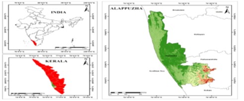
Flooding is one of the most destructive natural disasters, capable of causing significant damage to infrastructure, ecosystems, and human lives. It is triggered by a variety of factors such as persistent rainfall, rapid snowmelt, rising sea levels, cloudbursts and anthropogenic activities. This study focuses on mapping flood-prone areas in the Alappuzha district of Kerala using the Weighted Overlay Method for flood risk mapping, the research integrates geospatial techniques such as Remote Sensing (RS) and Geographic Information Systems (GIS) to create a flood inundation map. Key parameters include physical factors like slope, drainage density, rainfall, geomorphology, soil, land use, NDVI, NDBI, MNDWI, and WRI, along with social factors such as population, households, building conditions, and access to information. The analysis reveals that low-lying areas near water bodies, including Cherthala, Ambalapuzha, and Kuttanad, are highly susceptible to flooding, intensified by poor drainage infrastructure. Kuttanad situated below sea level, faces frequent floods, severely impacting agriculture and livelihoods. Southern taluks like Karthikappally and Mavelikkara, although at higher altitudes, still face moderate flood risks due to proximity to minor rivers. This study underscores the importance of integrating geospatial data and hydrological models for effective flood risk assessment and sustainable flood management practices.
Keywords
Land use, NDVI, NDBI, MNDWI, WRI, Natural Disaster, Weighted Overlay Method, Key Parameters, Water Bodies, flood management
© 2022 Sreelekshmi et al. This is an open-access article distributed under the terms of the Creative Commons Attribution License, which permits unrestricted use, distribution, and reproduction in any medium, provided the original author and source are credited.
Published By Bangalore University, Bengaluru, Karnataka
Subscribe now for latest articles and news.