Geo-Eye

Department of Geography & GIS

Article

Geo-Eye

Year: 2023, Volume: 12, Issue: 1, Pages: 12-19

Original Article

Delineation of Groundwater Potential Zones for Mavinahallikere Sub-Watershed of Kadur Taluk in Chikmagalur District, Karnataka State, Using Geospatial Technique

Received Date:25 January 2023, Accepted Date:14 April 2023

Abstract

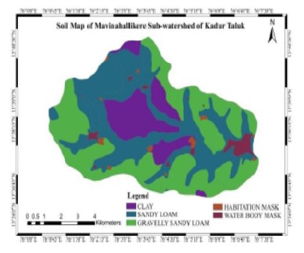
The present study shows the importance of remote sensing and geographical information system, which is found to be an effective tool for delineating groundwater potential zones of Mavinahallikere sub-watershed. Resource maps along with field investigation done to evaluate potential groundwater zones for the study area. The survey of India topographical map No. 57C/2 as the base and IRS LISS-IV satellite image (2015) used to prepare the thematic layers like drainage, lithology, geomorphology, lineaments, slope, land use/land cover and contours. The groundwater contour maps were prepared based on well details collected during fieldwork. Each unit of all thematic layers assigned with rank based on IMSD guideline and later integrated in the GIS platform to generate the groundwater potential map. The result shows that five distinct zones such as very poor, poor, moderate, good, and very good zones.

Keywords: Groundwater; Potential zones, Remote sensing, GIS

References

  1. Engman ET, Gurney RJ. Remote sensing in hydrology. (pp. 1-225) Netherlands. Springer. 1991.
  2. Jha MK, Chowdhury A, Chowdary VM, Peiffer S. Groundwater management and development by integrated remote sensing and geographic information systems: prospects and constraints. Water Resources Management. 2007;21(2):427–467. Available from: https://doi.org/10.1007/s11269-006-9024-4
  3. Waikar ML, Nilawar AP. Identification of groundwater potential zone using remote sensing and GIS technique. International Journal of Innovative Research in Science, Engineering and Technology. 2014;3(5):12163–12174. Available from: https://www.researchgate.net/publication/271690625_Identification_of_Groundwater_Potential_Zone_using_Remote_Sensing_and_GIS_Technique
  4. Rao PJ, Harikrishna P, Srivastav SK, Satyanarayana PVV, Rao BVD. Selection of groundwater potential zones in and around Madhurawada Dome, Visakhapatnam District - A GIS approach. Journal of Indian Geophysical Union. 2009;13(4):191–200. Available from: http://iguonline.in/journal/Archives/13-4/21jagadeesh.pdf
  5. Pandiyan PS, Annadurai R. Groundwater Potential Zoning at Kancheepuram using GIS Techniques. IRACST – Engineering Science and Technology: An International Journal (ESTIJ). 2013;3(1):23–32.
  6. Murugesan V, Krishnaraj S, Kannusamy V, Selvaraj G, Subramanya S. Groundwater potential zoning in Thirumanimuttar sub-basin Tamilnadu, India—A GIS and remote sensing approach. Geo-spatial Information Science. 2011;14(1):17–26. Available from: https://doi.org/10.1007/s11806-011-0422-2
  7. Waters P, Greenbaum D, Smart PL, Osmaston H. Applications of remote sensing to groundwater hydrology. Remote Sensing Reviews. 1990;4(2):223–264. Available from: https://doi.org/10.1080/02757259009532107
  8. Selvam S, Magesh NS, Sivasubramanian P, Soundranayagam JP, Manimaran G, Seshunarayana T. Deciphering of groundwater potential zones in Tuticorin, Tamil Nadu, using remote sensing and GIS techniques. Journal of the Geological Society of India. 2014;84(5):597–608. Available from: https://doi.org/10.1007/s12594-014-0167-2

Copyright

© 2023 Govindaraju et al. This is an open-access article distributed under the terms of the Creative Commons Attribution License, which permits unrestricted use, distribution, and reproduction in any medium, provided the original author and source are credited.

Published By Bangalore University, Bengaluru, Karnataka 

DON'T MISS OUT!

Subscribe now for latest articles and news.