Geo-Eye

Department of Geography & GIS

Article

Geo-Eye

Year: 2019, Volume: 8, Issue: 2, Pages: 6-11

Review Article

Urban growth and development in Mandya taluk using GIS and remote sensing

Received Date:11 June 2019, Accepted Date:21 November 2019

Abstract

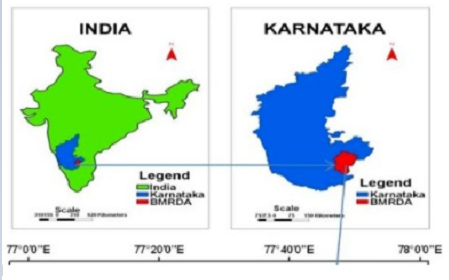
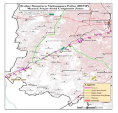
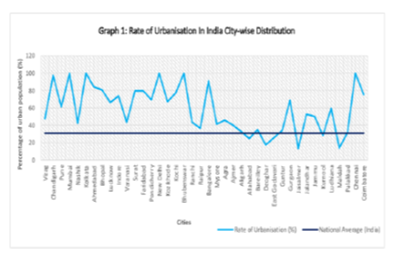
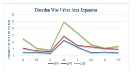
Even though they are conceptually different, the terms urban growth, urban extension, and urban sprawl are occasionally used interchangeably. An increase in the urbanised land cover is referred to as urban growth. Urban extension is one method of urban expansion. Urban sprawl is the term for urban growth that occurs as a result of unplanned or spontaneous urban development. Urban sprawl usually has negative connotations, associated with the generation or intensification of complex urban problems, such as land, water, and air pollution, with their consequent negative impacts on human health (Alberti, 1999; Antrop, 2004; Dickson, Baker, Hoornweg, & Asmita, 2012; Kumar & Pandey, 2013; Marshall, Pielke, Steyaert, & Willard, 2004; Pathan, Shukla, Patel, Patel, & Mehta, 1991; Rivas, Hernandez, & Cueto, 2003;Claudia, Sandra, Sergio, Jorge, 2019). Manya tauk, in the Indian state of Karnataka, is one of the fastest growing urban centres. In the last three decades, the taluk has seen a surge in urban growth and development in all directions. And it is expected to grow at a faster rate in the future. The satellite images of LandSat 5 TM, LandSat 7 ETM+ and LandSat 8 OLI/TIRS sensors for years 1995, 2005 and 2018 respectively is collected from Earth Explorer provided by USGS. Using a shape file of the study area downloaded from Diva GIS, supervised classification was also performed for the study areas using ERDAS Imagine 2014, and finally an agricultural thematic map was created using Arc GIS 10.2 version.

Keywords: Urban Growth; GIS; Remote sensing

References

  1. Alberti M. Modeling the urban ecosystem: a conceptual framework. Environment and Planning B: Planning and Design. 1999;26:605–630. doi: 10.1068/
  2. Yeh 2AGO, Li X. A Constrained CA Model for the Simulation and Planning of Sustainable Urban Forms by Using GIS. Environment and Planning B: Urban Analytics and City Science. 2001;28(5):733–753. Available from: https://doi.org/10.1068/b2740
  3. Bryant CR, Russwurm LJ, McLellan AG. The City's Countryside: Land and Its Management in the Rural-Urban Fringe. 1982.
  4. Barrington-Leigh C, Millard-Ball A. Global trends toward urban street-network sprawl. Proceedings of the National Academy of Sciences. 2020;117:1941–1950. Available from: https://dx.doi.org/10.1073/pnas.1905232116
  5. Dickson E;, Baker JL, Hoornweg D;, Tiwari A. Urban Risk Assessments: Understanding Disaster and Climate Risk in Cities. Urban Development. 2012. Available from: https://openknowledge.worldbank.org/handle/10986/12355
  6. Daniels T. Where Does Cluster Zoning Fit in Farmland Protection? Journal of the American Planning Association. 1997;63(1):129–137.
  7. Ewing R. Is Los Angeles-Style Sprawl Desirable? Journal of the American Planning Association. 1997;63(1):107–126. Available from: https://dx.doi.org/10.1080/01944369708975728
  8. Shi G, Shan J, Ding L, Ye P, Li Y, Jiang N. Urban Road Network Expansion and Its Driving Variables: A Case Study of Nanjing City. International Journal of Environmental Research and Public Health. 2019;16(13):2318. Available from: https://dx.doi.org/10.3390/ijerph16132318
  9. Gordon P, Richardson HW. Are Compact Cities a Desirable Planning Goal? Journal of the American Planning Association. 1997;63(1):95–106. Available from: https://dx.doi.org/10.1080/01944369708975727
  10. Marshall CH, Pielke RA, Steyaert LT, Willard DA. The Impact of Anthropogenic Land-Cover Change on the Florida Peninsula Sea Breezes and Warm Season Sensible Weather. Monthly Weather Review. 2004;132(1):28–52. Available from: https://dx.doi.org/10.1175/1520-0493(2004)132<0028:tioalc>2.0.co;2
  11. Pathan S, Shukla V, Patel R, Patel B, Mehta K. Urban land use mapping: A case study of ahmedabad city and its environs. Journal of the Indian Society of Remote Sensing. 1991;19(2):95–112. Available from: https://dx.doi.org/10.1007/bf03008125
  12. Rivas S, Hernandez R, Cueto JL. Evaluation and prediction of noise pollution levels in urban areas of Cdiz (Spain) The Journal of the Acoustical Society of America. 2003;114(4):2439. Available from: https://dx.doi.org/10.1121/1.4779173
  13. Yang H, Bell MGH. Models and algorithms for road network design: a review and some new developments. Transport Reviews. 1998;18(3):257–278. Available from: https://dx.doi.org/10.1080/01441649808717016
  14. Lämmer S, Gehlsen B, Helbing D. Scaling laws in the spatial structure of urban road networks. Physica A: Statistical Mechanics and its Applications. 2006;363(1):89–95. Available from: https://dx.doi.org/10.1016/j.physa.2006.01.051

Copyright

© 2019 Hanjagi et al.  This is an open-access article distributed under the terms of the Creative Commons Attribution License, which permits unrestricted use, distribution, and reproduction in any medium, provided the original author and source are credited.

Published By Bangalore University, Bengaluru, Karnataka

DON'T MISS OUT!

Subscribe now for latest articles and news.