Geo-Eye

Department of Geography & GIS

Article

Geo-Eye

Year: 2018, Volume: 7, Issue: 1, Pages: 43-52

Original Article

Morphometric analysis for peak discharge estimation of sub and micro watersheds of Vedavathy river sub basin, Karnataka

Received Date:19 March 2018, Accepted Date:22 May 2018

Abstract

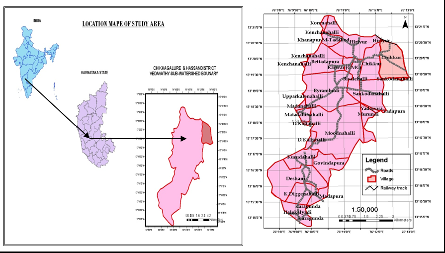
IRS and GIS technology are extensively used for basin analysis which helps in monitoring the development and management of watershed and its catchment areas. The present study was carried to estimate peak discharge of two mini and micro watershed of the Krishna river basin, the two watersheds selected for the above study are Chikkur sub-watershed and Lailapura micro watershed which forms a part of Vedavathy river sub-basin and falls under Krishna river basin lying in between Karagunda and Hiriyur village of Chikamagalur & Hassan districts in Karnataka. The satellite image used for the study are Ortho_rectified Cartosat -1(2.5m), digital elevation model (DEM) data & LISS-IV (5.86m) are used for extraction of basin Morphometric parameters, database generation using NRIS resource layers and Automatic delineation of the watershed under Arc GIS Environment. Morphometric Analysis of Chikkur subwatershed have shown less relief ratio, high ruggedness number, time of concentration, drainage density stream frequency, mean bifurcation ratio, and less form factor. Lailapura micro watershed has shown high relief ratio, form factor and time of concentration fewer ruggedness numbers, stream frequency. The peak discharge of Chikkur subwatershed is 46.56 cusecs and Lailapura micro watershed is 10.31 cusecs for 160mm of rain respectively.

Keywords: ­ sub­watershed, Krishna river basin, Vedavathy river sub­basin, and Morphometric Analysis, peak discharge estimation

References

  1. Strahler AN. Quantitative analysis of watershed geomorphology. Transactions, American Geophysical Union. 1957;38(6):913–920. Available from: https://dx.doi.org/10.1029/tr038i006p00913
  2. Singh SR. A drainage morphological approach for water resources development of the sur catchment, Vidarbha region. Journal of the Indian Society of Remote Sensing. 2006;34(1):79–88.
  3. Bhatt S, Ahmed SA. Morphometric analysis to determine floods in the Upper Krishna basin using Cartosat DEM. Geocarto International. 2014;29(8):878–894. Available from: https://dx.doi.org/10.1080/10106049.2013.868042
  4. Chopra R, Dhiman RD, Sharma PK. Morphometric analysis of sub-watersheds in Gurdaspur district, Punjab using remote sensing and GIS techniques. Journal of the Indian Society of Remote Sensing. 2005;33(4):531–539. Available from: https://dx.doi.org/10.1007/bf02990738
  5. Javed A, Khanday MY, Ahmed R. Prioritization of sub-watersheds based on morphometric and land use analysis using remote sensing and GIS techniques. Journal of the Indian Society of Remote Sensing. 2009;37(2):261–274. doi: 10.1007/s12524-009-0016-8
  6. Strahle AN. Hypsometric (area-altitude) analysis of erosional topography. Geological Society of America Bulletin. 1952;63(11):1117–1142. Available from: https://dx.doi.org/10.1130/0016-7606(1952)63[1117:haaoet]2.0.co;2
  7. Rao KHVD, Singh AK, Roy PS. Study of morphology and suspended sediment of Bhopal Upper Lake using spatial simulation technique and remote sensing data. Journal of the Indian Society of Remote Sensing. 2009;37(3):433–441. Available from: https://dx.doi.org/10.1007/s12524-009-0034-6
  8. Smith KG. Standards for grading texture of erosional topography. American Journal of Science. 1950;248(9):655–668.
  9. Amutha R, Porchelvan P. Estimation of surface runoff in Malattar sub-watershed using SCS-CN method. Journal of the Indian Society of Remote Sensing. 2009;37(2):291–304. doi: 10.1007/s12524-009-0017-7
  10. Ahmed SA, Chandrashekarappa KN, Raj SK, Nischitha V, Kavitha G. Evaluation of morphometric parameters derived from ASTER and SRTM DEM — A study on Bandihole sub-watershed basin in Karnataka. Journal of the Indian Society of Remote Sensing. 2010;38(2):227–238. Available from: https://dx.doi.org/10.1007/s12524-010-0029-3
  11. Thakkar AK, Dhiman SD. Morphometric analysis and prioritization of miniwatersheds in Mohr watershed, Gujarat using remote sensing and GIS techniques. Journal of the Indian Society of Remote Sensing. 2007;35(4):313–321. Available from: https://dx.doi.org/10.1007/bf02990787
  12. Rudraiah M, Govindaiah S, Vittala SS. Morphometry using remote sensing and GIS techniques in the sub-basins of Kagna river basin, Gulburga district, Karnataka, India. Journal of the Indian Society of Remote Sensing. 2008;36(4):351–360. Available from: https://dx.doi.org/10.1007/s12524-008-0035-x
  13. Singh SR. A drainage morphological approach for water resources development of the sur catchment, Vidarbha region. Journal of the Indian Society of Remote Sensing. 2006;34(1):79–88.
  14. Fairfield J, Leymarie P. Drainage networks from grid digital elevation models. Water Resources Research. 1991;27(5):709–717. Available from: https://dx.doi.org/10.1029/90wr02658

Copyright

© 2018 Mayachar et al.  This is an open-access article distributed under the terms of the Creative Commons Attribution License, which permits unrestricted use, distribution, and reproduction in any medium, provided the original author and source are credited.

Published By Bangalore University, Bengaluru, Karnataka

DON'T MISS OUT!

Subscribe now for latest articles and news.