Geo-Eye
Department of Geography & GIS
Department of Geography & GIS
Geo-Eye
Year: 2023, Volume: 12, Issue: 1, Pages: 41-45
Original Article
S Sushmitha1, B Chandrashekara2
1 Research Scholar, Department of Studies in Geography, University of Mysore, Mysuru
2 Professor, Department of Studies in Geography, University of Mysore, Mysuru
Received Date:12 March 2023, Accepted Date:18 June 2023
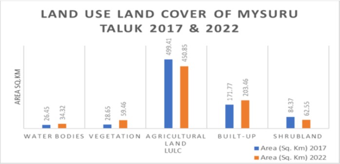
The research places its emphasis on comprehending the intricacies and fluctuations in the utilization and coverage of land in Mysuru Taluk, a locale nestled in the southern reaches of India. The study uses Sentinel-2 multitemporal satellite data from the Esri to examine land dynamics in Mysuru Taluk between 2017 and 2022, employing ArcMap software for mapping and statistical techniques for quantifying variations in land cover categories such as built-up areas, agricultural land, and water bodies. The investigation endeavors to pinpoint the catalysts that have influenced the transformation of land utilization in this area, which encompasses the realms of urbanization, agricultural practices, and environmental shifts. The findings of this study unveil a decline in shrublands and agricultural land, while simultaneously witnessing an upsurge in vegetation and urbanized areas within Mysuru Taluk, spanning the years from 2017 to 2022. The dwindling of shrublands and agricultural land can be ascribed to alterations in natural vegetation patterns, land management methodologies, and land use policies, particularly those related to urbanization. Conversely, the augmentation of vegetation and urbanized areas signifies an escalating inclination towards afforestation, conservation endeavors, population expansion, and urban development within this region.
Keywords
Land use and land cover changes, Mysuru Taluk, LULC classification, Urban regions, Agricultural land, Natural habitats, Geographical information systems (GIS), Built up areas, Afforestation initiatives, Conservation efforts
© 2023 Sushmitha & Chandrashekara. This is an open-access article distributed under the terms of the Creative Commons Attribution License, which permits unrestricted use, distribution, and reproduction in any medium, provided the original author and source are credited.
Subscribe now for latest articles and news.