Geo-Eye
Department of Geography & GIS
Department of Geography & GIS
Geo-Eye
Year: 2018, Volume: 7, Issue: 1, Pages: 38-42
Original Article
O Mohammed Faizan1
1B.E. Geo-Informatics, Institute of Remote Sensing, College of Engineering Guindy, Anna University
Received Date:12 March 2018, Accepted Date:08 April 2018
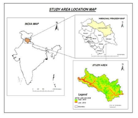
A major factor in sustainable development and humanitarian response to global change in land use and land cover change. In global environmental change, land use and land cover play an important role and contributes significantly to earth-atmosphere interactions and the loss of biodiversity. The distribution of land cover in the region is closely linked to climatic conditions. For a wide variety of applications, such as landslide and erosion management, land planning, Disaster management, etc., mapping of land use and land cover change is important. In this study, land use and land cover mapping carried out using GIS and remote sensing in Lahul – Spiti District of Himachal Pradesh. Landsat 7 and 8 data of the years 2005, 2010, 2015 and 2019 have been used for land use and land cover mapping. The maps for LULC produced using supervised classification techniques using the maximum likelihood classification (MLC) algorithm. Supervised classification methods have been used for delineating five major classes: snow/glacier, barren/rocky surface, forest, agriculture/grass, and water. LULC maps have been prepared using ArcGIS 10.8. Forest cover reduced from 4.34% in 2005 to 1.58% in 2019. Same way Snow/Glacier has increased from 27.31 percent to nearly 39.15 percent in the year 2019. Agriculture practice has decreased from 13.06 % to 6.92% in the year 2019. The slope area that represents the barren land in the study area is reduced from 55.22% to 52.29% in 2019. The area under water also reduced by 0.06% in 2005 to 0.04% in 2019.
Keywords
Landuse/Landcover (LULC), GIS, remote sensing, supervised classification, Himachal Pradesh
© 2018 Faizan. This is an open-access article distributed under the terms of the Creative Commons Attribution License, which permits unrestricted use, distribution, and reproduction in any medium, provided the original author and source are credited.
Published By Bangalore University, Bengaluru, Karnataka
Subscribe now for latest articles and news.