Geo-Eye
Department of Geography & GIS

Department of Geography & GIS

Geo-Eye
Year: 2019, Volume: 8, Issue: 2, Pages: 32-38
Original Article
V Nischitha1
1Department of Geography and GIS, Jnanabharathi, Bangalore University, Bangalore, Karnataka, India
Received Date:06 July 2019, Accepted Date:18 November 2019
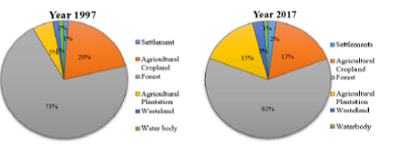
Mapping and monitoring of land use land cover is essential for many management and planning activities as it is considered as an important element for understanding the earth and its whole system. The present study focused on the utilization of remote sensing and GIS technology for land use land cover classification and its change analysis for local areas like Thirthahalli over the period of two decades. Multitemporal satellite imagery of the Landsat series was used to map land use land cover changes in the years 1997 and 2017. Supervised classification using Maximum Likelihood technique was used resulting in the classes: forest, agricultural plantations, agricultural croplands, wastelands, water bodies and settlement areas. The study showed the major changes occurred in forest, agricultural plantations and settlement classes. Modifications in the pattern of agricultural activities are the main reasons for the changes in land use land cover distributions in the study area during the study period.
Keywords: LULC; Change Detection; Remote Sensing; GIS; Thirthahalli
© 2019 Nischitha. This is an open-access article distributed under the terms of the Creative Commons Attribution License, which permits unrestricted use, distribution, and reproduction in any medium, provided the original author and source are credited.
Published By Bangalore University, Bengaluru, Karnataka
Subscribe now for latest articles and news.