Geo-Eye
Department of Geography & GIS
Department of Geography & GIS
Geo-Eye
Year: 2021, Volume: 10, Issue: 1, Pages: 22-26
Original Article
R Shiva Kumar1, Afsana Tabassum2
1Guest Faculty, Department of Geography & Geoinformatics, Bangalore University, Bengaluru
2M.sc in GIS, Department of Geography & Geoinformatics, Bangalore University, Bengaluru
Received Date:19 January 2021, Accepted Date:20 April 2021
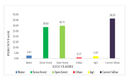
This study mainly focusses on changes of land use land cover (LULC) in Bandipur National Park in 2001, 2011and 2019. Methodology have been used for LULC analysis, downloaded satellite imageries of Landsat 8 (OLI) for 2019, Landsat (ETM+) for 2001, and Landsat 4-5 (TM) for 2011. with the help of Geoinformatics tools clipped the area with 5 km buffer in context to our study area and processed it with supervised classification of water, dense forest, open forest, urban, agriculture, current fallow to get LULC map for the study area. In three decades, areawise changes noticed in LULC analysis revealed the open forest is more than the dense forest as it is getting decreased. The area under water is also getting decreased in the past two decades. The total area under cultivation i.e., areas under agriculture and horticulture have increasing. And the urban is increasing in the Bandipur National Park (BNP) by 1% in all the three decadal period.
Keywords: Land Use Land Cover (LULC); Bandipur National Park (BNP); Landsat
© 2021 Kumar & Tabassum. This is an open-access article distributed under the terms of the Creative Commons Attribution License, which permits unrestricted use, distribution, and reproduction in any medium, provided the original author and source are credited.
Published By Bangalore University, Bengaluru, Karnataka
Subscribe now for latest articles and news.