Geo-Eye
Department of Geography & GIS
Department of Geography & GIS
Geo-Eye
Year: 2020, Volume: 9, Issue: 1, Pages: 33-37
Original Article
I A Mulla1
1Associate Professor, Head Department of Geography, Anjuman Arts, Sci, Com., College & P.G. Studies, Dharwad, Karnataka, India
Received Date:17 March 2020, Accepted Date:22 May 2020
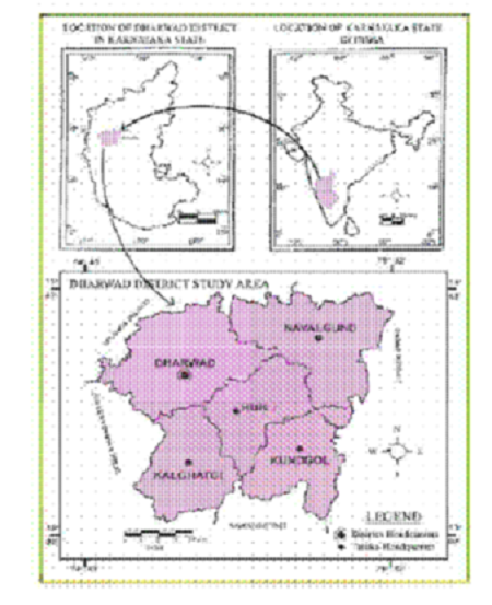
Irrigation in India has been practiced from ancient times and irrigation tanks and wells are a familiar feature of the India landscape to supplement and conserve the rainfall. Artificial lakes and canals that dot the country in the hundred are centuries old and some of them has served for more than thousand years. Storages and their water courses are common in south, central and eastern India. Hindu monarchs and the Mughal emperors later on, the Britishers undertook a large number of irrigation works. Water is needed in almost every sphere of human activity. Irrigation through major and medium canal systems was a key component of green revolution that transformed India and made the spectre of famines in India history. Irrigated agriculture is thus responsible for the rapid improvement in the agriculture productivity in the 1960’s, 70s, and 80’s. There is a marked difference in the levels of contribution from agriculture in the rain-fed and the irrigated areas. In general irrigation is seen to be affecting poverty by increasing returns to the physical, human and social capital; integrating the poor with factor, product and information markets and improving the overall national growth rates. Among taluks, the area of corps, production and productivity of crops are higher in Dharwad and Navalgund taluks owing to more area under irrigation. Even horticulture crops are also more in these two taluks as compared to other taluks as a consequence of more area under irrigation. The available utilizable water resource of the District, viz: Dharwad, Hubli, Kalghatgi, Kundagol, Navalgund; is considered insufficient to meet all the future needs. Under such a situation, in order to face the challenge of water deficit, apart from accelerating pace of development of available utilizable water resources, all out efforts, on the part of people from every walk of life, would need to be made to conserve every drop of water and improve efficiency in all areas of water use.
Keywords: Irrigation; Sources of Irrigation; Yielding; Cropping; Agriculture Economy
© 2020 Mulla. This is an open-access article distributed under the terms of the Creative Commons Attribution License, which permits unrestricted use, distribution, and reproduction in any medium, provided the original author and source are credited.
Published By Bangalore University, Bengaluru, Karnataka
Subscribe now for latest articles and news.