Geo-Eye
Department of Geography & GIS
Department of Geography & GIS
Geo-Eye
DOI: 10.53989/bu.ge.v14.i2.25.27
Year: 2025, Volume: 14, Issue: 2, Pages: 51-61
Original Article
Roouf Ahmad Malla1*, Irfan Hassan Ganaie1, Sunil Yuvraj Narke2
1Ahmednagar College, Ahmednagar, India.
2Jamkhed Mahavidyalaya, Jamkhed, Ahmednagar, India
Received Date:09 November 2025, Accepted Date:22 December 2025
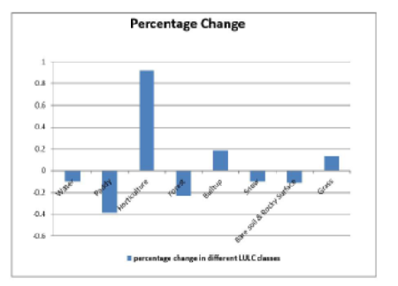
Kulgam, often referred to as the “Rice Bowl of Jammu and Kashmir,” has witnessed significant land use and land cover changes over the past two decades. The research reports extensive and serious transformations of different land cover classes in Kulgam district as identified via remote sensing technologies to characterize spatial and temporal patterns of comprehensive land use and land cover changes for the period from 2011 to 2021. Using the maximum likelihood classification method, a supervised classification approach, eight major land use categories were identified. The results show significant increases in horticulture (92.2%), built-up areas (18.4%), and grass lands (13.7%). Conversely, several land use classes reported a declining trend. Paddy cultivation decreased by (-38.3%), forest by (-23.2%), bare soil & rocky surface by (-11%), water bodies by (-10%), and snow contracted by (-10%). The primary drivers of land use change in the region are identified as climate change, population growth, and economic factors. However, agricultural intensity has also been an aggravating factor for land use and land cover change. The rise of horticulture, and changes in land use policies have also played a significant role in shaping the landscape dynamics of the study area.
Keywords: Land use/Land cover Change, Remote Sensing, Supervised Classification, Climate Change
1. Ahmed P, Mir AA. (2014). Sediment yield estimation for watershed management in Lolab watershed of Jammu & Kashmir state using geospatial tools. <I>International Journal of Advanced Remote Sensing and GIS</I>, 3(1), 616-626.
2. Ahmed R, Wani GF, Ahmad ST, Sahana M, Singh H, Ahmed P. A Review of Glacial Lake Expansion and Associated Glacial Lake Outburst Floods in the Himalayan Region. Earth Systems and Environment. 2021; 5 (3). Available from: https://doi.org/10.1007/s41748-021-00230-9
3. Amin A, Fazal S. Quantification of Land Transformation Using Remote Sensing and GIS Techniques. American Journal of Geographic Information System. 2012; 1 (2). Available from: https://doi.org/10.5923/j.ajgis.20120102.01
4. Anderson JR, Hardy EE, Roach JT, Witmer RE. A land use and land cover classification system for use with remote sensor data. Professional Paper. 1976; 964 Available from: https://doi.org/10.3133/pp964
5. Briassoulis H, Verhey WH. Factors influencing land-use and land-cover change, Land-use, Land-cover and Soil Sciences. <I>Land Use, Land Cover and Soil Sciences</I>. 1(2003)
6. Chadha SK (1990) Ecological crisis in Kashmir. In: Chadha SK (ed) <I>Ecology of Kashmir</I>. Ashish Publishing House, New Delhi, pp 56–73
7. Chen S, Zeng S, Xie C. (2000). Remote sensing and GIS for urban growth analysis in China. <I>Photogrammetric Engineering and Remote Sensing</I>, 66(5), 593-598.
8. Chen X, Vierling L, Deering D. A simple and effective radiometric correction method to improve landscape change detection across sensors and across time. Remote Sensing of Environment. 2005; 98 (1). Available from: https://doi.org/10.1016/j.rse.2005.05.021
9. Congalton RG. A review of assessing the accuracy of classifications of remotely sensed data. Remote Sensing of Environment. 1991; 37 (1). Available from: https://doi.org/10.1016/0034-4257(91)90048-b
10. Ellis E, Pontius RG. (2006). Land-use and land-cover change—encyclopedia of earth. <I>Environ. Protect</I>, 2, 142-153.
11. Fayaz A, Shafiq MU, Singh H, Ahmed P. Assessment of spatiotemporal changes in land use/land cover of North Kashmir Himalayas from 1992 to 2018. Modeling Earth Systems and Environment. 2020; 6 (2). Available from: https://doi.org/10.1007/s40808-020-00750-9
12. Foley JA, DeFries R, Asner GP, Barford C, Bonan G, Carpenter SR, <I>et al</I>. Global consequences of land use. Science. 2005; 309 (5734). Available from: https://doi.org/10.1126/science.1111772
13. Foody GM. Status of land cover classification accuracy assessment. Remote Sensing of Environment. 2002; 80 (1). Available from: https://doi.org/10.1016/s0034-4257(01)00295-4
14. Gao J, Liu Y. Determination of land degradation causes in Tongyu County, Northeast China via land cover change detection. International Journal of Applied Earth Observation and Geoinformation. 2010; 12 (1). Available from: https://doi.org/10.1016/j.jag.2009.08.003
15. Giri C, Zhu Z, Reed B. A comparative analysis of the Global Land Cover 2000 and MODIS land cover data sets. Remote Sensing of Environment. 2005; 94 (1). Available from: https://doi.org/10.1016/j.rse.2004.09.005
16. Hassan Z, Shabbir R, Ahmad SS, Malik AH, Aziz N, Butt A, <I>et al</I>. Dynamics of land use and land cover change (LULCC) using geospatial techniques: a case study of Islamabad Pakistan. SpringerPlus. 2016; 5 (1). Available from: https://doi.org/10.1186/s40064-016-2414-z
17. Ingram K, Knapp E, Robinson JW. (1981). Change detection technique development for improved urbanized area delineation. <I>NASA, Comput. Sci. Corp., Springfield, MD, CSC/TM-81/6087</I>.
18. Kumar BP, Babu KR, Rajasekhar M, Ramachandra M. Identification of land degradation hotspots in semiarid region of Anantapur district, Southern India, using geospatial modeling approaches. Modeling Earth Systems and Environment. 2020; 6 (3). Available from: https://doi.org/10.1007/s40808-020-00794-x
19. Lesschen JP, Verburg PH, Staal SJ. (2005) <I>Statistical methods for ana lysing the spatial dimension of changes in land use and farming systems</I>. LUCC report series 7. The International Livestock Research Institute, Nairobi, Kenya and LUCC Focus 3 Office, Wageningen University, The Netherlands
20. López M, <I>et al</I>. (2021). Climate Change and Its Impact on Agricultural Land Use. <I>Global Environmental Change</I>, 71, 102314.
21. Luna RA, Robles CA. Land use land cover changes and costal lagoon surface reduction associated with urban growth in north west Mexico. Landscape Ecology. 2003; 18 (2). Available from: https://doi.org/10.1023/a:1024461215456
22. Mahmood R, Pielke RA, Hubbard KG, Niyogi D, Bonan G, Lawrence P, <I>et al</I>. Impacts of Land Use/Land Cover Change on Climate and Future Research Priorities. Bulletin of the American Meteorological Society. 2010; 91 (1). Available from: https://doi.org/10.1175/2009bams2769.1
23. Malla RA, <I>et al</I>. An Analysis of Conversion of Paddy Land into Apple Orchards of District Kulgam. <I>Journal Of Critical Reviews</I>, Vol 07, Issue 19, 2020
24. Mandal S, Bandyopadhyay A, Bhadra A. Dynamics and future prediction of LULC on Pare River basin of Arunachal Pradesh using machine learning techniques. Environmental Monitoring and Assessment. 2023; 195 (6). Available from: https://doi.org/10.1007/s10661-023-11280-z
25. Meyer WB. (1995). Past and Present Land Use and Land Cover in the U. S. A. <I>Consequences: The nature and implications of environmental change</I>, 1(1).
26. Moshen A (1999). <I>Environmental land use change detection and assessment using multi-temporal satellite imagery</I>. Zanjan University, Zanjan
27. Nelson RF. (1983). Detecting forest canopy change due to insect activity using Landsat MSS. <I>Photogrammetric Engineering and Remote Sensing</I>, 49(9), 1303-1314.
28. Nuñez MN, Ciapessoni HH, Rolla A, Kalnay E, Cai M. Impact of land use and precipitation changes on surface temperature trends in Argentina. Journal of Geophysical Research: Atmospheres. 2008; 113 (D6). Available from: https://doi.org/10.1029/2007jd008638
29. Olofsson P, Foody GM, Stehman SV, Woodcock CE. Making better use of accuracy data in land change studies: Estimating accuracy and area and quantifying uncertainty using stratified estimation. Remote Sensing of Environment. 2013; 129 Available from: https://doi.org/10.1016/j.rse.2012.10.031
30. Pelorosso R, Leone A, Boccia L. Land cover and land use change in the Italian central Apennines: A comparison of assessment methods. Applied Geography. 2009; 29 (1). Available from: https://doi.org/10.1016/j.apgeog.2008.07.003
31. Rahaman S, Kumar P, Chen R, Meadows ME, Singh RB. Remote Sensing Assessment of the Impact of Land Use and Land Cover Change on the Environment of Barddhaman District, West Bengal, India. Frontiers in Environmental Science. 2020; 8 Available from: https://doi.org/10.3389/fenvs.2020.00127
32. Rahman A, Kumar S, Fazal S, Siddiqui MA. Assessment of Land use/land cover Change in the North-West District of Delhi Using Remote Sensing and GIS Techniques. Journal of the Indian Society of Remote Sensing. 2012; 40 (4). Available from: https://doi.org/10.1007/s12524-011-0165-4
33. Rembold F, Carnicelli S, Nori M, Ferrari GA. Use of aerial photographs, Landsat TM imagery and multidisciplinary field survey for land-cover change analysis in the lakes region (Ethiopia). International Journal of Applied Earth Observation and Geoinformation. 2000; 2 (3-4). Available from: https://doi.org/10.1016/s0303-2434(00)85012-6
34. Romshoo SA, Fayaz M, Meraj G, Bahuguna IM. Satellite-observed glacier recession in the Kashmir Himalaya, India, from 1980 to 2018. Environmental Monitoring and Assessment. 2020; 192 (9). Available from: https://doi.org/10.1007/s10661-020-08554-1
35. Rwanga SS, Ndambuki JM. Accuracy Assessment of Land Use/Land Cover Classification Using Remote Sensing and GIS. International Journal of Geosciences. 2017; 08 (04). Available from: https://doi.org/10.4236/ijg.2017.84033
36. Sala OE, Stuart Chapin FIII, Armesto JJ, Berlow E, Bloomfield J, Dirzo R, <I>et al</I>. Global Biodiversity Scenarios for the Year 2100. Science. 2000; 287 (5459). Available from: https://doi.org/10.1126/science.287.5459.1770
37. Sarma PK, Lahkar BP, Ghosh S, Rabha A, Das JP, Nath NK, <I>et al</I>. (2008) Land use and land cover change and future implication analysis in Manas National Park, India using multi temporal satellite data. <I>Current Science</I>. 95(2):223–227
38. Shafiq MU, Rasool R, Ahmed P, Dimri AP. Temperature and Precipitation trends in Kashmir valley, North Western Himalayas. Theoretical and Applied Climatology. 2019; 135 (1-2). Available from: https://doi.org/10.1007/s00704-018-2377-9
39. Singh A. Review article digital change detection techniques using remotely-sensed data. International Journal of Remote Sensing. 1989; 10 (6). Available from: https://doi.org/10.1080/01431168908903939
40. Song XP, Hansen MC, Stehman SV, Potapov PV, Tyukavina A, Vermote EF, <I>et al</I>. Global land change from 1982 to 2016. Nature. 2018; 560 (7720). Available from: https://doi.org/10.1038/s41586-018-0411-9
41. Story M, Congalton RG (1986) Accuracy assessment: a user’s perspective. <I>Photogrammetric Engineering & Remote Sensing</I> 52(3):397–399
42. Talkhabi H, Ghalehteimouri KJ, Mehranjani MS, Zanganeh A, Karami T. Spatial and temporal population change in the Tehran Metropolitan Region and its consequences on urban decline and sprawl. Ecological Informatics. 2022; 70 Available from: https://doi.org/10.1016/j.ecoinf.2022.101731
43. Talukdar S, Singha P, Mahato S, Pal S, Liou YA, Rahman A. Land-Use Land-Cover Classification by Machine Learning Classifiers for Satellite Observations—A Review. Remote Sensing. 2020; 12 (7). Available from: https://doi.org/10.3390/rs12071135
44. Vali A, Comai S, Matteucci M. Deep Learning for Land Use and Land Cover Classification Based on Hyperspectral and Multispectral Earth Observation Data: A Review. Remote Sensing. 2020; 12 (15). Available from: https://doi.org/10.3390/rs12152495
45. Vitousek P, Mooney H, Lubchenco J, Melillo JM. Human Domination of Earth's Ecosystems. Science. 1997; 277 (5325). Available from: https://doi.org/10.1126/science.277.5325.494
46. Xiao J, Shen Y, Ge J, Tateishi R, Tang C, Liang Y, <I>et al</I>. Evaluating urban expansion and land use change in Shijiazhuang, China, by using GIS and remote sensing. Landscape and Urban Planning. 2006; 75 (1-2). Available from: https://doi.org/10.1016/j.landurbplan.2004.12.005
47. Zhang Y, <I>et al</I>. (2019). Urban Expansion and Land Use Change: A Case Study of Southeast Asia. <I>Land Use Policy</I>, 89, 104232.
© 2025 Malla et al. This is an open-access article distributed under the terms of the Creative Commons Attribution License, which permits unrestricted use, distribution, and reproduction in any medium, provided the original author and source are credited.
Published By Bangalore University, Bengaluru, Karnataka
Subscribe now for latest articles and news.