Geo-Eye

Department of Geography & GIS

Article

Geo-Eye

Year: 2023, Volume: 12, Issue: 2, Pages: 54-58

Original Article

Analysing the Shoreline Dynamics Along the Southern Coastal Region of Kerala: A Case Study of Kollam District in Kerala

Received Date:24 August 2023, Accepted Date:18 December 2023

Abstract

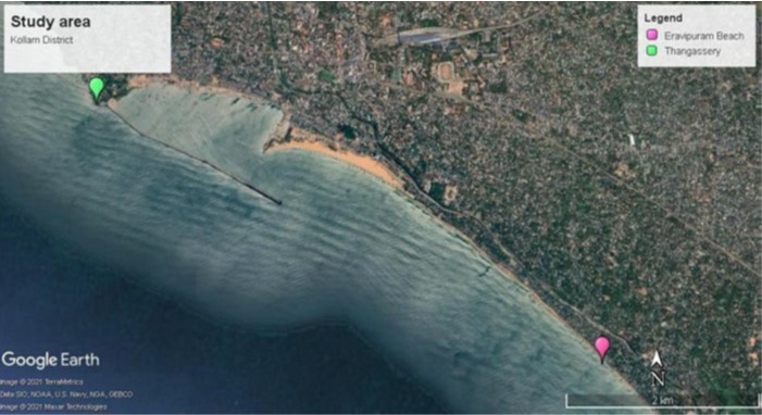
Shoreline change is considered to be a serious issue because of the changing nature of oceans and its influence on people and land. The vital term shoreline can be defined as the rate at which shore gets worn or accreted due to wave action, sea level-rise or any supplementary hazards and processes that affect the land. All the natural processes are conserved to attain their equilibrium, coast as a physical feature is always in a dynamic state trying to change, and nature continually works for preserving its balance. The coastal regions of India are specified with varied ecosystem, high productivity and thickly populated, has increased its very own importance. The coastal areas are subjected to vulnerable hazards, and it affects the coastal community and its geomorphic features. The present study has been conducted along the coastal areas of southern Kerala, especially Kollam district with the help of multi- temporal satellite images of the years 1973, 1988, 2002, 2018 and 2022. The Digital Shoreline Analysis System (DSAS) technique is used for calculating the coastal erosion and accretion rates. The present study focuses on the pre and post tsunami effects and major and minor erosion and accretion occurred in Kollam. Tsunami is a series of waves caused by an earthquake, underwater volcanic eruption, landslide or other abrupt disturbances. The Indian Ocean tsunami of December 26, 2004, not only affected the Bay of Bengal coast of India, but also hit into the Arabian Sea coast with major damages in Kerala. Destructive waves were occurred through tsunami, and it has made changes in the coastal geomorphology. The study could be analyzed micro level shoreline change rate due to tsunami effects in association with anthropogenic activities occurred in the coastal areas of Kollam district.

Keywords

Digital Shoreline Analysis System (DSAS), Coastal Erosion, Accretion, Tsunami

References

  1. Furlani S, Devoto S, Biolchi S, Cucchi F. Factors Triggering Sea Cliff Instability Along the Slovenian CoastsJournal of coastal research2011;2011(10061):387393 . Available from: https://doi.org/10.2112/SI61-001.45
  2. Dolan R, Fenster MS, Holme SJ. Temporal analysis of shoreline recession and accretionJournal of Coastal Research1991;7(3):723744. Available from: https://www.jstor.org/stable/4297888
  3. Saranathan E, Chandrasekaran R, Manickaraj DS, Kannan M. Shoreline Changes in Tharangampadi Village, Nagapattinam District, Tamil Nadu, India—A Case StudyJournal of the Indian Society of Remote Sensing 2011;39(1):107115. Available from: https://doi.org/10.1007/s12524-010-0052-4
  4. Mahapatra M, Ratheesh R, Rajawat AS. Shoreline change analysis along the Coast of South Gujarat, India, using digital shoreline analysis systemJournal of the Indian Society of Remote Sensing2014;42(4):869876. Available from: https://doi.org/10.1007/s12524-013-0334-8
  5. Noujas V, Thomas KV. Erosion Hotspots along Southwest Coast of IndiaAquatic Procedia2015;4:548555. Available from: https://doi.org/10.1016/j.aqpro.2015.02.071
  6. Kumar TS, RSM, Nayak S, Radhakrishnan K. Coastal Vulnerability Assessment for Orissa State, East Coast of IndiaJournal of coast research2010;26:523534. Available from: http://dx.doi.org/10.2307/40605480
  7. TKM. Coastal zone management programme in Kerala, IndiaEnvironmental Geology and Water Sciences1987;10:95102. Available from: https://doi.org/10.1007/BF02574666
  8. Padmalal D, Kumaran KPN, Nair KM, Limaye RB, Mohan SV, Baijulal B, et al. Consequences of sea level and climate changes on the morphodynamics of a tropical coastal lagoon during Holocene: An evolutionary modelQuaternary International2014;333:156172. Available from: https://doi.org/10.1016/j.quaint.2013.12.018
  9. Nobi EP, Shivaprasad A, Karikalan R, Thangaradjou T, Shivakumar K, Dilipan E. Micro level Mapping of Coastal Resources of Rameswaram Island, India: A Remote Sensing and GIS Perspectives”Journal of Coastal Research2010;2010(263):424428. Available from: https://doi.org/10.2112/08-1119.1
  10. Jayakumar K, Malarvannan S. A Web GIS based decision support system for land use and land cover changes: a case study of Tiruvallur Block, Tamil NaduInternational Journal of Earth Sciences and Engineering2015;8(4):18921898.
  11. Noujas V, Thomas KV, Nair LS, Hameed TSS, Badarees KO, Ajeesh NR. Management of shoreline morphological changes consequent to breakwater constructionIndian Journal of Geo Marine Sciences2014;43(1):5461. Available from: https://nopr.niscpr.res.in/bitstream/123456789/26426/1/IJMS%2043(1)%2054-61.pdf
  12. Masselink G, Hughes MG. An Introduction to Coastal Processes and Geomorphology (1). Taylor and Francis ltd. 2003.
  13. SN. Coastal zone management in India − present status and future needsGeo-spatial Information Science2017;20(2):174183. Available from: https://doi.org/10.1080/10095020.2017.1333715
  14. Van TT, Binh TT. Application of remote sensing for shoreline change detection in Cuu Long estuaryVNU Ịournal of Science, Earth Sciences2009;25(4):217222. Available from: https://js.vnu.edu.vn/EES/article/view/1879
  15. Vinayaraj P, Johnson G, Dora GU, Philip CS, Kumar VS, Gowthaman R. Quantitative Estimation of Coastal Changes Along Selected Locations of Karnataka, India: A GIS and Remote Sensing ApproachInternational Journal of Geosciences2011;2:385393. Available from: https://dx.doi.org/10.4236/ijg.2011.24041

Copyright

© 2023 Vasanthakumari et al. This is an open-access article distributed under the terms of the Creative Commons Attribution License, which permits unrestricted use, distribution, and reproduction in any medium, provided the original author and source are credited.

Published By Bangalore University, Bengaluru, Karnataka

DON'T MISS OUT!

Subscribe now for latest articles and news.