Geo-Eye
Department of Geography & GIS

Department of Geography & GIS

Geo-Eye
Year: 2018, Volume: 7, Issue: 1, Pages: 15-17
Original Article
R Shiva Kumar1
1Guest Faculty, Department of Geography, Jnanabharathi Campus, Bangalore University, Bengaluru
Received Date:10 January 2018, Accepted Date:23 May 2018
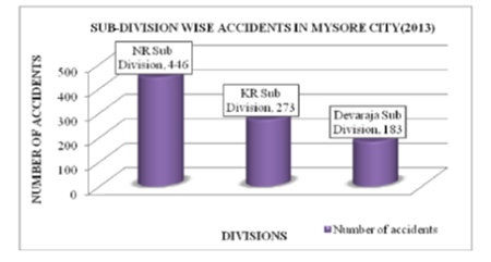
This research paper mainly focuses the road traffic Sub-division-wise accidents in Mysore City in the year of 2013.the methodology used in this study with the help of detailed accident data of 2013 collected from Krishnaraja, Devaraja, and Narasimaraja Traffic Police Stations. There are 902 total accidents that occurred in the year 2013, there are 141 deaths and many of them injured. For plotting the exact location of accident spots mainly used Global Positioning System (GPS) points of each accident. Arc GIS 10.3 software technology used for maps and analysis of three main sub-division-wise accidents spots in Mysore city. The result shows that compared to KR Sub Division and Devaraja Sub Division, the NR Sub Division is the highest number of (446) road traffic accident occurred in the year of 2013.
Keywords
Sub-division-wise, road traffic accident, global positioning system, GIS
© 2018 Kumar. This is an open-access article distributed under the terms of the Creative Commons Attribution License, which permits unrestricted use, distribution, and reproduction in any medium, provided the original author and source are credited.
Published By Bangalore University, Bengaluru, Karnataka
Subscribe now for latest articles and news.