Geo-Eye
Department of Geography & GIS

Department of Geography & GIS

Geo-Eye
DOI: 10.53989/bu.ge.v13i1.naseeba
Year: 2024, Volume: 13, Issue: 1, Pages: 27-29
Original Article
Umme Naseeba1∗
1 Assistant Professor in Geography, Government Arts College, Bengaluru-01, Karnataka, India
*Corresponding author email: [email protected]
Received Date:12 January 2024, Accepted Date:18 May 2024
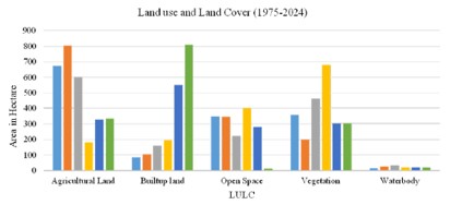
Nanjangud, a prominent town in the Mysore district of Karnataka, India, has experienced significant urban and industrial growth over the past few decades. This study aims to analyze the land use and land cover (LULC) changes in Nanjangud from 1975 to 2024 using Landsat and Sentinel satellite imagery at decade intervals. By employing supervised classification techniques, the research seeks to provide a comprehensive understanding of the spatial and temporal dynamics of urban expansion and its environmental impacts. The study leverages Geographic Information System (GIS) and remote sensing technologies to monitor and map these changes accurately. The findings indicate increase in urban built-up lands, accompanied by a reduction in open spaces, vegetal and agricultural lands highlighting the need for sustainable urban planning and management in the town.
Keywords
Urban Development, Urban Growth, GIS, Remote Sensing
© 2024 Naseeba. This is an open-access article distributed under the terms of the Creative Commons Attribution License, which permits unrestricted use, distribution, and reproduction in any medium, provided the original author and source are credited.
Published By Bangalore University, Bengaluru, Karnataka
Subscribe now for latest articles and news.