Geo-Eye
Department of Geography & GIS

Department of Geography & GIS

Geo-Eye
Year: 2018, Volume: 7, Issue: 2, Pages: 7-10
Original Article
R Shiva Kumar1*
1Guest Faculty, Department of Geography, Jnanabharathi Campus, Bangalore University, Bengaluru
Received Date:10 August 2018, Accepted Date:16 November 2018
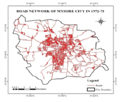
Developing countries such as India are experiencing rapid urban expansion and land-use change. The road is one of the most significant roles in connection with one place to another place. Moving from one place to another has become the main concern in today’s context Considerate the urban road network expansion pattern and its consistent social and environmental effects is a sensible way to enhance complete urban planning and keep the city maintainable. The creation of roads is exclusive to the extremely extensive forms of natural landscape disparity. This paper mainly emphasizes the road network development in Mysore city. to analyze the development of road network length Geographic Information System (GIS) technology used for plotting the maps. Toposheet have been used for road network maps of 1972-73, 2005-06, and 2016. And also, calculation of the increased road lengths.The land transformation causes the road network length was increased by 1719 kilometers between 1972- 73 to 2016.
Keywords: Road development; network; Mysore city; Geographic Information System
© 2018 Shiva Kumar. This is an open-access article distributed under the terms of the Creative Commons Attribution License, which permits unrestricted use, distribution, and reproduction in any medium, provided the original author and source are credited.
Published By Bangalore University, Bengaluru, Karnataka
Subscribe now for latest articles and news.