Geo-Eye
Department of Geography & GIS
Department of Geography & GIS
Geo-Eye
Year: 2018, Volume: 7, Issue: 2, Pages: 16-19
Original Article
K Prasad1, R Sunilkumar2, B Sukumar3
1Research scholar, P.G.& Research Dept. of Geography, Govt. Arts college, Coimbatore
2Asst. Prof. of Geography, P.G.& Research Dept. of Geography, Govt. Arts College, Coimbatore
3Scientist (Rtd.), NCESS, Thiruvananthapuram
Received Date:28 September 2018, Accepted Date:26 November 2018
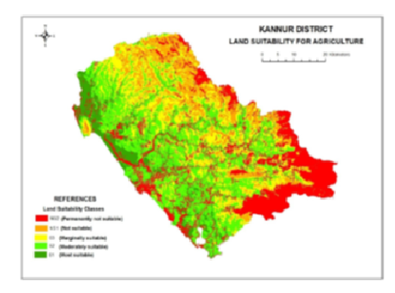
Land suitability is the fitness of a given type of land for a defined use. The land may be considered in its present condition or after improvements. There are several methods used for land suitability analysis. In the paper, an attempt is made to derive land suitability classes by considering relief, landforms, slope, aspect, topographic wetness index (TWI), soils, soil texture, and erosion-prone areas. The relief map is prepared by digitizing contours from the Survey of India’s topographic maps in 1:50,000 scale. SRTM data also used to derive contours, slope, aspect, and topographic wetness index. The study area is chosen in Kannur district in Kerala State. It is situated in the northern part of Kerala. All these eight parameters were digitized using ArcGIS software. Weighted overlay analysis was done for identifying land suitability for agriculture, and derived into different classes based on values and labeled as most suitable (S1), moderately suitable (S2), marginally suitable (S3), not suitable (NS1), and not suitable (NS2). This analysis will be useful for identifying the main limiting factors for agricultural production and enables decision-makers to develop crop management able to increase land productivity.
Keywords: Land suitability; topographic wetness index; Weighted overlay analysis
© 2018 Prasad et al. This is an open-access article distributed under the terms of the Creative Commons Attribution License, which permits unrestricted use, distribution, and reproduction in any medium, provided the original author and source are credited.
Published By Bangalore University, Bengaluru, Karnataka
Subscribe now for latest articles and news.