Geo-Eye
Department of Geography & GIS
Department of Geography & GIS
Geo-Eye
DOI: 10.53989/bu.ge.v14.i2.25.23
Year: 2025, Volume: 14, Issue: 2, Pages: 38-50
Original Article
Chaina Debnath1, Sajal Ghosh2*
1Student, Kazi Nazrul University, Asansol, West Bengal, India.
2Teacher, Department of Geography, Hiralal Bhakat College, Nalhati, West Bengal, India.
*Corresponding Author
Email: [email protected]
Received Date:28 August 2025, Accepted Date:22 November 2025
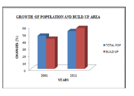
Urbanization, which is caused by economic and population growth, has far-reaching socioeconomic as well as environmental effects, such as pollution and land degradation. Future studies should develop reliable techniques for recognizing and forecasting urban growth trends in Asia. Rapid development and rising temperatures have led to significant changes in Durgapur Municipal Corporation's urban landscape and surface temperature, with the western sector experiencing the most growth, necessitating sustainable urban planning and resource management. In Durgapur-Faridpur, Andal, and Kanksa CD Blocks, the study surveys urbanization, population change, the relation between physical growth and population, and the LULC pattern in 2001-2011. Changes in land cover and urbanization are analyzed at the city level with Landsat 5 TM imagery obtained from 2001 to 2011. For improved classification and change detection analysis over a ten-year period, secondary data such as Census data and Google Earth maps is utilized. Supervised Classification using Maximum Likelihood Classification (MLC) was applied to prepare LULC maps of the study area. From this LULC maps by using Intersect Overlay tools from Arc Gis software the change detection map has been prepared. Durgapur Municipality Corporation and its surrounding areas 5 k.m. is a potential region marching towards urbanization due to the presence of Iron – steel industry and mining activities in this area. This paper emphasizes on the growth of urban area and effects of urbanization on environmental components mainly climate, biosphere, landuse pattern, water resources, waste disposal etc. Significant changes in landuse are as follows in this study area barren land 6.04% to 12.61% from 2001 to 2011, settlements 20.70% to 34.42% from 2001 to 2011, Ground 19.78% to 1.87% from 2001 to 2011. Major changes in population growth and built up area are 46.69% to 53.30% (2001 to 2011) and 42.37% to 57.62% (2001 to 2011). Urbanization and Industrialization are one of the major factors to increase environmental degradation.
Keywords: Urban Growth, Landuse Pattern, Barren Land, Settlement, Environmental, Maximum Likelihood Classification, LULC, Durgapur Municipality Corporation
1. Abebe MT, Megento TL. Urban green space development using GIS-based multi-criteria analysis in Addis Ababa metropolis. Applied Geomatics. 2017; 9 (4). Available from: https://doi.org/10.1007/s12518-017-0198-7
2. Aithal BH, Ramachandra TV. Visualization of Urban Growth Pattern in Chennai Using Geoinformatics and Spatial Metrics. Journal of the Indian Society of Remote Sensing. 2016; 44 (4). Available from: https://doi.org/10.1007/s12524-015-0482-0
3. Anees MM, Banzhaf E, Joshi PK, Mann D, Sharma M. Assessment of Urban Dynamics to Understand Spatiotemporal Differentiation at Various Scales Using Remote Sensing and Geospatial Tools. Remote Sensing. 2020; 12 (8). Available from: https://doi.org/10.3390/rs12081306
4. Bhatia SY, Patil GR, Buddhiraju KM. Analysing Urban Sprawl of the Mumbai Metropolitan Region using Remote Sensing and Socioeconomic Data. The International Archives of the Photogrammetry, Remote Sensing and Spatial Information Sciences. 2023; XLVIII-M-3-2023 Available from: https://doi.org/10.5194/isprs-archives-xlviii-m-3-2023-35-2023
5. Bhatta B. Analysis of urban growth pattern using remote sensing and GIS: a case study of Kolkata, India. International Journal of Remote Sensing. 2009; 30 (18). Available from: https://doi.org/10.1080/01431160802651967
6. Bihamta N, Gholamalifard M, Fakheran S, Soffianian A. Using the SLEUTH Urban Growth Model to Simulate Future Urban Expansion of the Isfahan Metropolitan Area, Iran. Journal of the Indian Society of Remote Sensing. 2015; 43 (2). Available from: https://doi.org/10.1007/s12524-014-0402-8
7. Boynton Tobey M, Chang S, Yamagata Y, Brent Binder R. Typologies of Rapid Urbanization in Developing Asian Countries: A Study of Shanghai’s Rapid Urbanization and Subsequent Strategies. IOP Conference Series: Earth and Environmental Science. 2019; 294 (1). Available from: https://doi.org/10.1088/1755-1315/294/1/012097
8. Cao H, Chen J, Chen C, Li P. Identification of multi-temporal urban growth patterns with a modified urban growth index: Case study of three fast growing cities in the Greater Mekong Subregion (GMS). Ecological Indicators. 2022; 142 Available from: https://doi.org/10.1016/j.ecolind.2022.109206
9. Carlucci M, Salvati L. Assessing path-dependent urban growth with geographically weighted regressions. Environmental Impact Assessment Review. 2023; 98 Available from: https://doi.org/10.1016/j.eiar.2022.106920
10. Chaiechi T, Tavares S, Wong C. Urban Design and Economic Growth: An Analytical Tale of Two Tropical Cities. eTropic: electronic journal of studies in the tropics. 2020; 19 (2). Available from: https://doi.org/10.25120/etropic.19.2.2020.3741
11. Chakraborty S, Maity I, Patel PP, Dadashpoor H, Pramanik S, Follmann A, <I>et al</I>. Spatio-temporal patterns of urbanization in the Kolkata Urban Agglomeration: A dynamic spatial territory-based approach. Sustainable Cities and Society. 2021; 67 Available from: https://doi.org/10.1016/j.scs.2021.102715
12. Choi H. Are we growing smart?: New vision for urban development in Asia and the Pacific. Asia-Pacific Development Journal. 2009; 15 (2). Available from: https://doi.org/10.18356/091f5e81-en
13. Cruz-Bello GM, Galeana-Pizaña JM, González-Arellano S. Urban growth in peri-urban, rural and urban areas: Mexico City. Buildings and Cities. 2023; 4 (1). Available from: https://doi.org/10.5334/bc.230
14. Debnath R, Amin AN. A geographic information system-based logical urban growth model for predicting spatial growth of an urban area. Environment and Planning B: Planning and Design. 2016; 43 (3). Available from: https://doi.org/10.1177/0265813515618565
15. Haldar S, Chatterjee U, Bhattacharya S, Paul S, Bindajam AA, Mallick J, <I>et al</I>. Peri-urban dynamics: assessing expansion patterns and influencing factors. Ecological Processes. 2024; 13 (1). Available from: https://doi.org/10.1186/s13717-024-00533-5
16. Haldar S, Mandal S, Bhattacharya S, Paul S. Dynamicity of Land Use/Land Cover (LULC) An analysis from peri-urban and rural neighbourhoods of Durgapur Municipal Corporation (DMC) in India. Regional Sustainability. 2023; 4 (2). Available from: https://doi.org/10.1016/j.regsus.2023.05.001
17. Ham E. Urbanization and Asian Lifestyles. The ANNALS of the American Academy of Political and Social Science. 1973; 405 (1). Available from: https://doi.org/10.1177/000271627340500111
18. Haque I, Patel PP. Growth of metro cities in India: trends, patterns and determinants. Urban Research & Practice. 2018; 11 (4). Available from: https://doi.org/10.1080/17535069.2017.1344727
19. Kamarajugedda SA, Mandapaka PV, Lo EYM. Assessing urban growth dynamics of major Southeast Asian cities using night-time light data. International Journal of Remote Sensing. 2017; 38 Available from: https://doi.org/10.1080/01431161.2017.1346846
20. Kamusoko C. Importance of Remote Sensing and Land Change Modeling for Urbanization Studies. The Urban Book Series. 2017; Available from: https://doi.org/10.1007/978-981-10-3241-7_1
21. Kontgis C, Schneider A, Fox J, Saksena S, Spencer JH, Castrence M. Monitoring peri-urbanization in the greater Ho Chi Minh City metropolitan area. Applied Geography. 2014; 53 Available from: https://doi.org/10.1016/j.apgeog.2014.06.029
22. Li X, Asrar GR, Yu S, Zhou Y, Eom J. Projecting Global Urban Area Growth Through 2100 Based on Historical Time Series Data and Future Shared Socioeconomic Pathways. Earth's Future. 2019; 7 (4). Available from: https://doi.org/10.1029/2019ef001152
23. Liu Y, Nath N, Murayama A, Manabe R. Transit-oriented development with urban sprawl? Four phases of urban growth and policy intervention in Tokyo. Land Use Policy. 2022; 112 Available from: https://doi.org/10.1016/j.landusepol.2021.105854
24. Majumdar S, Sivaramakrishnan L. Mapping of Urban Growth Dynamics in Kolkata Metropolitan Area: A Geospatial Approach. Contemporary South Asian Studies. 2020; Available from: https://doi.org/10.1007/978-3-030-23796-7_2
25. Nath SS, Kumar B. Demarcating Peri Urban Areas of Kolkata through Computer Modelling from Demographic Data. 2020 International Conference on Contemporary Computing and Applications (IC3A). 2020; Available from: https://doi.org/10.1109/ic3a48958.2020.233304
26. Nong DH, Fox JM, Lepczyk CA, Miura T. Quantifying urban growth patterns in Hanoi using landscape expansion modes and time series spatial metrics. PLOS ONE. 2018; 13 (5). Available from: https://doi.org/10.1371/journal.pone.0196940
27. Pavri F. Urban Expansion and Sea-Level Rise Related Flood Vulnerability for Mumbai (Bombay), India Using Remotely Sensed Data. Geospatial Techniques in Urban Hazard and Disaster Analysis. 2009; Available from: https://doi.org/10.1007/978-90-481-2238-7_3
28. Ramachandra TV, Sowmyashree MV, Bharath HA. Urban Footprint Of Mumbai - The Commercial Capital Of India. Journal of Urban and Regional Analysis. 2021; 6 (1). Available from: https://doi.org/10.37043/jura.2014.6.1.5
29. Rob U, Talukder MN. Urbanization Prospects in Asia: A Six-Country Comparison. International Quarterly of Community Health Education. 2013; 33 (1). Available from: https://doi.org/10.2190/iq.33.1.c
30. Roberts M. Urban Growth in South Asia: A View from Outer Space. Alternative Approaches in Macroeconomics. 2018; Available from: https://doi.org/10.1007/978-3-319-69676-8_11
31. Sahana M, Hong H, Sajjad H. Analyzing urban spatial patterns and trend of urban growth using urban sprawl matrix: A study on Kolkata urban agglomeration, India. Science of The Total Environment. 2018; 628-629 Available from: https://doi.org/10.1016/j.scitotenv.2018.02.170
32. Shafia A, Bharath HA, Gaurav S. Urban growth modelling using Cellular Automata coupled with land cover indices for Kolkata Metropolitan region. IOP Conference Series: Earth and Environmental Science. 2018; 169 Available from: https://doi.org/10.1088/1755-1315/169/1/012090
33. Shandas V, Ferwati S, Makido Y. Rapid Urban Growth and Land Use Patterns in Doha, Qatar: Opportunities for Sustainability?. European Journal of Sustainable Development Research. 2018; 1 Available from: https://doi.org/10.20897/ejosdr.201711
34. Sinha S, Basu A. Chapter 11 - Assessing Urban Land-use Sustainability: Asansol Durgapur Planning Area, West Bengal, India. Water, Land, and Forest Susceptibility and Sustainability. 2023; 2 Available from: https://doi.org/10.1016/b978-0-443-15847-6.00002-1
35. Smith DA. Global cities in East Asia: empirical and conceptual analysis. International Social Science Journal. 2004; 56 (181). Available from: https://doi.org/10.1111/j.0020-8701.2004.00502.x
36. Suharto BB, Kusuma ME, Wijaya KAP. The implications of urban expansion to commuter travel behavior in the Jakarta Metropolitan Area. IOP Conference Series: Earth and Environmental Science. 2021; 737 (1). Available from: https://doi.org/10.1088/1755-1315/737/1/012020
37. Tah S, Roy SK, Mondal C. Assessment of Land Surface Temperature Using Landsat Images: A Case Study on Durgapur Municipal Corporation, West Bengal, India. Human Dynamics in Smart Cities. 2023; Available from: https://doi.org/10.1007/978-3-031-25914-2_9
38. Valerio Q, Anna B, Francesco C, Diego G, Dalila R, Piermaria C. Monitoring land take by point sampling: Pace and dynamics of urban expansion in the Metropolitan City of Rome. Landscape and Urban Planning. 2015; 143 Available from: https://doi.org/10.1016/j.landurbplan.2015.06.012
39. Weng Q. Modeling Urban Growth Effects on Surface Runoff with the Integration of Remote Sensing and GIS. Environmental Management. 2001; 28 (6). Available from: https://doi.org/10.1007/s002670010258
40. Yu W, Zhou W. Spatial pattern of urban change in two Chinese megaregions: Contrasting responses to national policy and economic mode. Science of The Total Environment. 2018; 634 Available from: https://doi.org/10.1016/j.scitotenv.2018.04.039
41. Zhu Y, Ling GHT. Spatio-Temporal Changes and Driving Forces Analysis of Urban Open Spaces in Shanghai between 1980 and 2020: An Integrated Geospatial Approach. Remote Sensing. 2024; 16 (7). Available from: https://doi.org/10.3390/rs16071184
© 2025 Debnath & Ghosh. This is an open-access article distributed under the terms of the Creative Commons Attribution License, which permits unrestricted use, distribution, and reproduction in any medium, provided the original author and source are credited.
Published By Bangalore University, Bengaluru, Karnataka
Subscribe now for latest articles and news.