Geo-Eye
Department of Geography & GIS

Department of Geography & GIS

Geo-Eye
Year: 2024, Volume: 13, Issue: 1, Pages: 34-38
Original Article
Sadanand Karun1∗
1 Research Scholar, International Institute for Population Sciences, Mumbai
*Corresponding author email: [email protected]
Received Date:02 August 2024, Accepted Date:12 September 2024
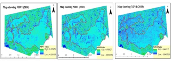
This study examines changes in forest cover within the Tikri Reserved Forest area, located in the eastern part of Gonda district of Uttar Pradesh. Data from Landsat-7 and Landsat-8 satellites, obtained from the USGS, were analyzed through Supervised Image Classification and the Normalized Difference Vegetation Index (NDVI) to assess changes in forest cover and vegetation health from 2010 to 2020. The analysis reveals a reduction in forest area by 670 hectares over the decade (2010-2020) and a decline in vegetation health, as indicated by decreasing NDVI values. The highest NDVI value in 2010 was 0.59 which reduced to 0.45 in 2020. These changes are attributed to illegal logging activities, often facilitated by corrupt practices among forest officials, and the overexploitation of forest resources to meet local demands. To mitigate further degradation and enhance forest health, the study advocates for stricter enforcement of conservation laws and more effective forest management practices.
Keywords
Tikri Reserved Forest, Remote Sensing, GIS, Forest Cover Change, Normalized Difference Vegetation Index (NDVI), LULC
© 2024 Karun. This is an open-access article distributed under the terms of the Creative Commons Attribution License, which permits unrestricted use, distribution, and reproduction in any medium, provided the original author and source are credited.
Published By Bangalore University, Bengaluru, Karnataka
Subscribe now for latest articles and news.