Geo-Eye
Department of Geography & GIS
Department of Geography & GIS
Geo-Eye
DOI: 10.53989/bu.ge.v15.i1.26.8
Year: 2026, Volume: 15, Issue: 1, Pages: 56-63
Original Article
Aritra Mondal1, Sajal Ghosh2*, Md Sayeed Anwar3, Sandeep Chandra4
1Research Scholar, University Department of Geography, Ranchi University, Ranchi, Jharkhand, India.
2Teacher, Department of Geography, Hiralal Bhakat College, Nalhati, West Bengal, India.
3Research Scholar, University Dept of Geography, Ranchi University, Ranchi, Jharkhand, India.
4Assistant Professor, Department of Geography, St. Xaviers College, Ranchi, Jharkhand, India
*Corresponding Author
Email: [email protected]
Received Date:16 March 2026, Accepted Date:07 August 2026
Groundwater is a crucial source of freshwater for drinking and irrigation, particularly in rural and semi-urban regions of developing countries. Rapid urbanization, population growth, and anthropogenic activities increasingly threaten groundwater quality. This study evaluates the spatial variation of groundwater quality across rural and urban areas of Ramgarh District, Jharkhand, India. A total of 51 groundwater samples were collected from wells, hand pumps, and tube wells across six administrative blocks during the post-monsoon period of December 2025. Key hydrochemical parameters including pH, Total Dissolved Solids (TDS), and Electrical Conductivity (EC) were analysed and compared with World Health Organization (WHO) and Bureau of Indian Standards (BIS) guidelines. The results indicate that pH values in both rural and urban areas remain within permissible limits, suggesting neutral groundwater conditions. However, urban areas exhibit higher TDS and EC values compared to rural areas, indicating greater mineralization and potential anthropogenic influence. The spatial maps produced in this study provide a useful baseline for monitoring groundwater quality and identifying safe and vulnerable zones for future water resource management in the district.
Keywords: Groundwater Quality; Rural–Urban Comparison; Hydrochemical Parameters; Spatial Analysis; Ramgarh District
The world's greatest freshwater supply for rural and semi-urban people, groundwater is the purest natural water source and serves as a risk buffer during dry spells[39]. In these geographic areas, groundwater is essential for drinking supplies. According to UNESCO (2015), one-third of the world's population now solely relies on groundwater[61]. Groundwater is the water that permeates every void in a geological stratum. Water makes up the majority of the earth's crust, which acts as a reservoir and a conduit for information[21]. As the need for high-quality water in homes, businesses, and agriculture has grown, groundwater is favored because of its wider spread and lesser contamination[12]. Surface water and precipitation provide groundwater with replenishment. The natural replenishment that comes from streams and other natural water sources, the man-made recharge process, and the water that falls on the earth naturally as a result of precipitation are all examples[2]. Due to the severe groundwater scarcity in Indian regions, many research have been conducted to find possible areas. Global models that combine remote sensing technology and GIS are being created[14]. India's 60-65 million inhabitants are consuming contaminated groundwater, causing harm to 3 million people, primarily in Rajasthan, Punjab, Gujarat, Madhya Pradesh, Uttar Pradesh, Jharkhand, Andhra Pradesh, and Tamilnadu[56]. Remote sensing technology effectively collects vast data on groundwater's movement, migration, and recharge, providing micro-level insights into various characteristics[1]. Groundwater potential zone mapping is made easier with RS and GIS, which are dependable, economical, and time-efficient methods for water management and conservation[13].
The greatest freshwater supply in the world, groundwater is the purest natural resource and provides rural and semi-urban communities with a buffer against risk during dry spells[40]. In these geographic areas, groundwater is essential for drinking supplies. Currently, a third of the world's population is solely dependent on groundwater[61]. The earth's crust contains the majority of groundwater, a type of water that permeates all geological layers and serves as a reservoir and a conduit for transmission[21]. As the need for high-quality water in homes, businesses, and agriculture has grown, groundwater is favored because of its wider spread and lesser contamination[12]. Precipitation, surface water from both natural and artificial sources, and man-made recharge mechanisms all contribute to the replenishment of groundwater[2]. Remote sensing data and GIS exploration help with resource evaluation and conservation by addressing groundwater management issues brought on by urbanization, population increase, climate change, and erratic rainfall[10].
As it indicates the salinity hazard to crops, measuring electrical conductivity is an excellent way to evaluate water quality for irrigation[32, 53].
Groundwater quality differs from place to place and this may therefore affect its suitability for consumption[60], For example, land-use has been found to affect the quality of groundwater[44, 60]. Polluted groundwater resource may initiate water-borne diseases such as gastroenteritis, cholera, typhoid fever and giardiasis[60].
Flow and transport processes affecting urban groundwater are not essentially different from those affecting groundwater in rural contexts, but the time and space scales involved are significantly different[29].
Urban groundwater systems are under increasing stress from rapid, unplanned urbanization, with contamination arising from industrial effluents, poor sanitation, agricultural runoff, and improper waste disposal[57]. Rapid, often unplanned urbanization has led to significant groundwater degradation driven by industrial discharges, leachate from urban solid waste dumps, and infiltration of domestic wastewater[38, 57]. Urbanization is a human-induced process that changes land use and land cover (LULC), as well as the amount and quality of surface and groundwater resources, particularly in urban and peri-urban areas[31, 35, 43]. The uneven distribution of water across time (temporal) and space (spatial) as well as the increased consumption and usage along with the problems of pollution, contamination, misuse and wastage; have given rise to water crisis in different parts of the world[15]. Surface waters are the best sinks for several point and non-point sources of pollution such as wastewater from agricultural and industrial processes, storm runoff amongst others[16, 42, 45]. The assessment frameworks presented can be applied to aquifer-wide monitoring and health risk assessment in other arsenic-affected urban and rural regions[9, 20, 40, 52]. The increasing population density, urbanization, and industrialization are driving forces to exceed groundwater extraction over recharge, decrease in water level and degradation of groundwater quality[46, 54].While groundwater is traded in some regions of the world, it is also widely used as a supply of water for home, industrial, agricultural, and energy generation operations[11, 26, 47-49, 65]. Sustainable groundwater development is not only constrained by resource availability but also by quality deterioration[24]. Whether it be through an increase in food production, a rise in farmers’ incomes or the creation of jobs in the farm sector and other associated sectors, irrigation improves the economic situation of rural households[19].
Groundwater has become indispensable for sustaining agriculture under such conditions. It serves as a buffer during dry periods, supports crop production when surface water is restricted, and contributes to stabilizing rural livelihoods[4].
The main source water supply in most developing economies is groundwater from shallow wells[22, 23, 33, 37, 55]. Research assesses the physicochemical features and heavy metal concentrations in the Ranchi district in Jharkhand state, India, and represents the groundwater quality via different pollution indices[34].
Despite the growing importance of groundwater studies in Jharkhand, limited research has examined spatial differences between rural and urban groundwater quality in Ramgarh district using field-based hydrochemical parameters.
To evaluate spatial patterns across rural and urban spaces in groundwater quality using key hydrochemical parameters
To assess suitability for drinking and irrigation as per WHO and BIS standards.
To identify the main natural and anthropogenic factors controlling spatial variability in groundwater quantity and quality.
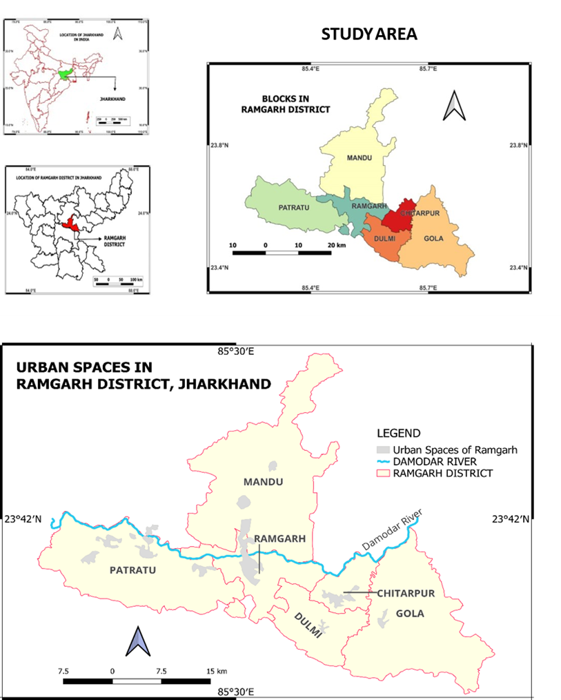
Ramgarh district is located in the North eastern part of the state of Jharkhand. Ramgarh district covers an area of approximately 1341 km2. This district is the centre of the Tri-important districts of Jharkhand namely Ranchi, Hazaribagh, and Bokaro. This proximity facilitates economic and social interaction which provides a cause to investigate groundwater standards as in recent times groundwater is a major resource and more recently a highly exploited resource. A study of Ramgarh district will allow to serve as a base for further studies.
Topography: The water table in topographic highs is usually deep, whereas in topographic lows it is shallow. This means that on topographic highs there is sufficient space for the water table to change. This space is lacking in topographic lows where the water table is often close to the surface[28]. Topography and climate are important controls on runoff response distribution (RRD) peak height, with topographic slope and the aridity index being the most influential factors[17]. Groundwater occurrence is influenced by the climate, physiography, drainage and geology of the area[36]. The influence of topography on the global terrestrial water cycle, from the atmosphere down to the groundwater[25]. Topography affects the distribution of water on Earth, often in surprising or extreme ways[25]. Distributions of water table depth often mirror surface topography. High up in the landscape, water tables tend to be deep, while at low elevations where water converges, water tables tend to be shallow[25]. Quartz vein and dolerite dyke act as a barrier for the movement of groundwater[18, 50]. Geospatial technologies are essential for groundwater potential assessment and evaluation considering significant controlling factors such as geology and topography[30, 41, 59].
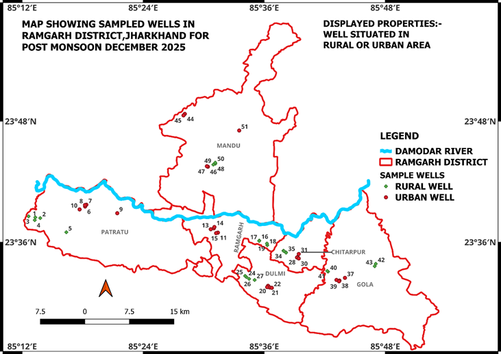
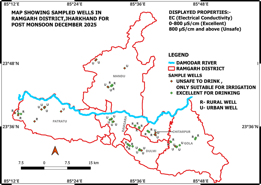
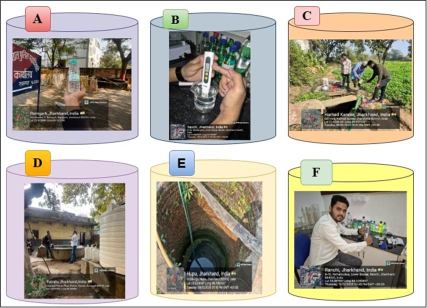
Sample collection: The samples were collected from the selected area via tube wells, hand pumps and wells. Sampling locations utilizing a GPS and thus as others. A total of 51 groundwater samples were collected, including 25 rural wells, 25 urban wells, and 1 well from a mining area in Mandu block as a case study., including field-measured pH, TDS, EC, well depth, elevation, GPS coordinates, and site photographs. Wells were selected using a stratified sampling approach to ensure representation across all six administrative blocks during the post monsoonal month of December 2025.
Laboratory Analysis: Electrical Conductivity (EC) was derived from Total Dissolved Solids (TDS) using standard conversion methods using the multiple 0.64. A Konvio water testing kit was use to obtain the values.
Statistical Analysis: Mean of values for each block and were performed to evaluate groundwater quality parameters. The analytical findings derived from the subsurface water samples are compared with the designated thresholds outlined in the WHO regulations governing drinking water.
Overall, the finding can be visualised as given in [Table. 1].
The data is better elaborated as follows with each parameter explained and interpreted separately and thereafter compared to global (WHO) and Indian (BIS) standards.
|
Param- |
WHO |
BIS |
Urban |
Rural |
Interpretation |
|---|---|---|---|---|---|
|
pH |
6.5-9.5 |
6.5-8.5 |
7.01 |
7.02 |
Both rural and urban groundwater show neutral condi- tions and remain well within permi- ssible limits. |
|
TDS |
1000 |
500 |
601.81 |
323.79 |
Urban groundwater shows higher mine- ral content and slightly exceeds BIS desirable limit, while rural water remains within safe limits. |
|
EC |
1500 |
780 |
940.37 |
505.96 |
Urban areas exhibit higher ionic conc- entration indicating greater minerali- zation, whereas rural groundwater remains within acceptable limits. |
pH:
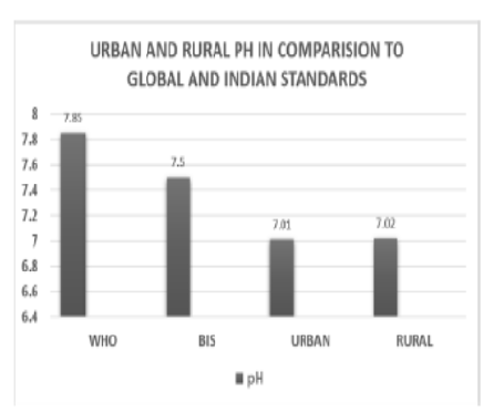
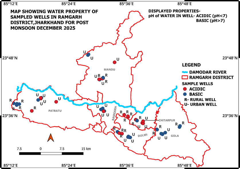
The pH determines the acidity and alkalinity of groundwater as a significant water quality parameter. The permissible limit of pH ranged from 6.5 to 9.5 as per WHO recommendations and 6.5 to 8.5 according to BIS standards for drinking purposes. Average Urban pH 7.01, Average Rural pH 7.02.
The minimal variation between rural and urban values suggests that land-use differences have not significantly influenced groundwater acidity or alkalinity. Such stable pH conditions may be attributed to the buffering capacity of local geological formations and natural groundwater recharge processes.
Total dissolved solids (TDS): Total Dissolved solids comprise of organic matter and inorganic salts, which may originate from sources such as sewage, effluent discharge, urban run-off or from natural bicarbonates, chlorides, sulphate, nitrate, sodium, potassium, calcium and magnesium TDS indicate fully dissolved minerals, such as calcium, chlorides, carbonates, bicarbonates, magnesium, silica, and sodium, in groundwater. The higher TDS levels in urban areas suggest greater mineralization, possibly influenced by urban runoff, wastewater infiltration, and increased human activities
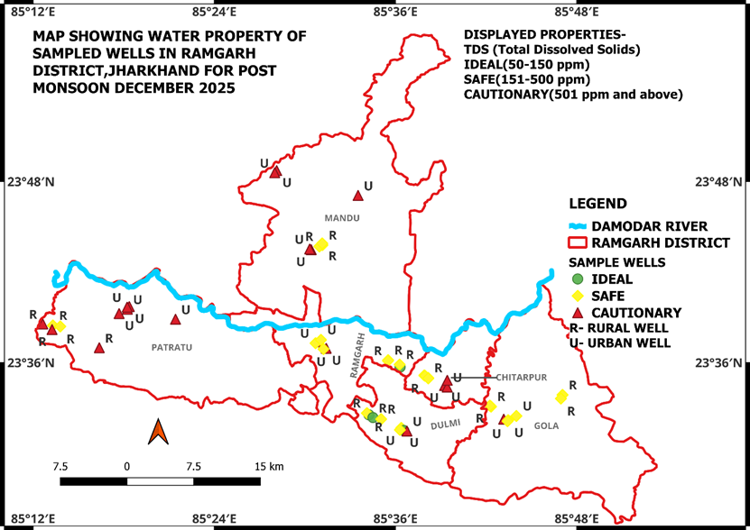
Electrical conductivity (EC): Electrical conductivity is a measure of ion concentrations that depends on the temperature and type of ions and their concentrations in the water. EC is directly proportional to the dissolved material in a water sample. The desirable limit of EC for drinking purpose is 750 µS/cm. The comparatively higher EC in urban areas indicates greater dissolved ion concentration, which may be associated with urbanization, mining activity, and higher groundwater extraction in the district.
|
Area |
Average TDS (mg/L) |
Average EC (µS/cm) |
|---|---|---|
|
Urban |
601.81 |
940.37 |
|
Rural |
323.79 |
505.96 |
pH:
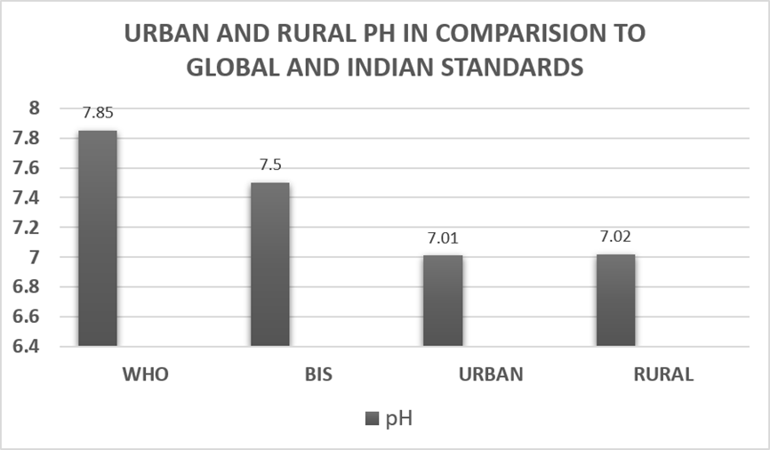
Comparison with international and national standards shows that pH levels in both rural and urban groundwater remain within safe limits. However, TDS and EC values are higher in urban areas, indicating moderate mineralization compared to rural groundwater. While the values remain within WHO permissible limits, the slight exceedance of BIS desirable limits in urban areas suggests growing anthropogenic influence on groundwater quality. The spatial maps produced in this study help identify relatively safer rural zones and comparatively stressed urban areas, providing a useful baseline for future groundwater monitoring and management.
TDS and EC:
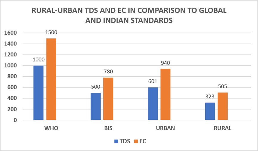
The present study assessed groundwater quality in rural and urban areas of Ramgarh district using key hydrochemical parameters including pH, Total Dissolved Solids (TDS), and Electrical Conductivity (EC). The results indicate that groundwater in both rural and urban areas remains neutral in pH and within the permissible limits of WHO and BIS standards, suggesting no immediate concern regarding acidity or alkalinity. However, urban groundwater shows comparatively higher TDS and EC values, reflecting greater mineralization likely influenced by urban activities, wastewater infiltration, and mining-related processes within the district. In contrast, rural groundwater appears relatively fresher and more suitable for drinking purposes.
The spatial distribution maps generated in this study provide a useful baseline reference for future groundwater monitoring and planning. Future research should focus on seasonal groundwater assessment, inclusion of additional physicochemical and heavy metal parameters, and long-term monitoring to evaluate temporal changes. Further studies may also incorporate water quality indices and geospatial modelling techniques to better understand the impact of urbanization and mining activities on groundwater sustainability in the region.
1. Abirami C, Annadurai R. Identification of Groundwater Potential Zones in Dehradun using GIS and AHP-Based Multi-Criteria Analysis. 2026; Available from: https://doi.org/10.22541/essoar.15007107/v2
2. Adamala S, Narakatla R, Durisety L. Analysis of Groundwater Potential Zones using RS & GIS Techniques in Khammam District, Telangana. 2020; Available from: https://www.researchgate.net/publication/346083980_Analysis_of_groundwater_potential_zones_using_RS_GIS_techniques_in_Khammam_District_Telangana
3. Ahamed JA. A comparative evaluation of groundwater suitability for drinking and irrigation purposes in Pugalur area, Karur district, Tamilnadu, India. Scholars Research Library Archives of Applied Science Research. 2013; 5 (1). Available from: www.scholarsresearchlibrary.com
4. Al-Shihmani LSS, Al-Sarraji AJ, Al-Shammary AAG, Fernández-Gálvez J, Caballero-Calvo A. Groundwater Quality Near Riverbanks and Its Suitability for Agricultural Use in Semi-Arid Regions. Applied Sciences. 2025; 15 (22). Available from: https://doi.org/10.3390/app152212338
5. Aravinthasamy P, Karunanidhi D, Subba Rao N, Subramani T, Srinivasamoorthy K. Irrigation risk assessment of groundwater in a non-perennial river basin of South India: implication from irrigation water quality index (IWQI) and geographical information system (GIS) approaches. Arabian Journal of Geosciences. 2020; 13 (21). Available from: https://doi.org/10.1007/s12517-020-06103-1
6. Asadi E, Isazadeh M, Samadianfard S, Ramli MF, Mosavi A, Nabipour N, et al. Groundwater Quality Assessment for Sustainable Drinking and Irrigation. Sustainability. 2019; 12 (1). Available from: https://doi.org/10.3390/su12010177
7. Atta Khan R, Zain SM, Juahir H, Yusoff MK, Hanidza T. Using Principal Component Scores and Artificial Neural Networks in Predicting Water Quality Index. Chemometrics in Practical Applications. 2012; Available from: https://doi.org/10.5772/32577
8. Ayyandurai R, Suresh M, Venkateswaran S. Evaluation of Groundwater for Irrigational Purposes in Cumbum Valley Theni District Tamilnadu India. International Journal of Innovative Technology and Exploring Engineering. 2013; 2 (3). Available from: https://www.ijitee.org/wp-content/uploads/papers/v2i3/C0461022313.pdf
9. Ayyasamy PM, Shanthi K, Lakshmanaperumalsamy P, Lee SJ, Choi NC, Kim DJ. Two-stage removal of nitrate from groundwater using biological and chemical treatments. Journal of Bioscience and Bioengineering. 2007; 104 (2). Available from: https://doi.org/10.1263/jbb.104.129
10. Baghel S, Tripathi MP, Khalkho D, Al-Ansari N, Kumar A, Elbeltagi A. Delineation of suitable sites for groundwater recharge based on groundwater potential with RS, GIS, and AHP approach for Mand catchment of Mahanadi Basin. Scientific Reports. 2023; 13 (1). Available from: https://doi.org/10.1038/s41598-023-36897-5
11. Bhatt S, Weiss DJ, Cameron E, Bisanzio D, Mappin B, Dalrymple U, et al. The effect of malaria control on Plasmodium falciparum in Africa between 2000 and 2015. Nature. 2015; 526 (7572). Available from: https://doi.org/10.1038/nature15535
12. Biswas A, Arkoprovo B, Adarsa J, Prakash SS. Delineation of Groundwater Potential Zones using Satellite Remote Sensing and Geographic Information System Techniques: A Case study from Ganjam district, Orissa, India. Research Journal of Recent Sciences. 2012; 1 (9). Available from: https://scispace.com/papers/delineation-of-groundwater-potential-zones-using-satellite-2icuyv52a2
13. Chaudhary BS, Kumar S. Identification of Groundwater Potential Zones using Remote Sensing and GIS of K-J Watershed, India. Journal of the Geological Society of India. 2018; 91 (6). Available from: https://doi.org/10.1007/s12594-018-0929-3
14. Das N, Mukhopadhyay S. Application of multi-criteria decision making technique for the assessment of groundwater potential zones: a study on Birbhum district, West Bengal, India. Environment, Development and Sustainability. 2020; 22 (2). Available from: https://doi.org/10.1007/s10668-018-0227-7
15. Dev R, Bali M. Evaluation of groundwater quality and its suitability for drinking and agricultural use in district Kangra of Himachal Pradesh, India. Journal of the Saudi Society of Agricultural Sciences. 2019; 18 (4). Available from: https://doi.org/10.1016/j.jssas.2018.03.002
16. Edokpayi JN, Odiyo JO, Durowoju OS. Impact of Wastewater on Surface Water Quality in Developing Countries: A Case Study of South Africa. Water Quality. 2017; Available from: https://doi.org/10.5772/66561
17. Eslami Z, Seybold H, Kirchner JW. Climatic, topographic, and groundwater controls on runoff response to precipitation: evidence from a large-sample data set. Available from: https://doi.org/10.5194/egusphere-2025-35
18. Fauzia Surinaidu L, Rahman A, Ahmed S. Distributed groundwater recharge potentials assessment based on GIS model and its dynamics in the crystalline rocks of South India. Scientific Reports. 2021; 11 (1). Available from: https://doi.org/10.1038/s41598-021-90898-w
19. Fischer C, Aubron C, Trouvé A, Sekhar M, Ruiz L. Groundwater irrigation reduces overall poverty but increases socioeconomic vulnerability in a semiarid region of southern India. Scientific Reports. 2022; 12 (1). Available from: https://doi.org/10.1038/s41598-022-12814-0
20. Foster S, MacDonald A. The ‘water security’ dialogue: why it needs to be better informed about groundwater. Hydrogeology Journal. 2014; 22 (7). Available from: https://doi.org/10.1007/s10040-014-1157-6
21. Ganapuram S, Kumar GTV, Krishna IVM, Kahya E, Demirel MC. Mapping of groundwater potential zones in the Musi basin using remote sensing data and GIS. Advances in Engineering Software. 2009; 40 (7). Available from: https://doi.org/10.1016/j.advengsoft.2008.10.001
22. Ganiyu SA, Badmus BS, Olurin OT, Ojekunle ZO. Evaluation of seasonal variation of water quality using multivariate statistical analysis and irrigation parameter indices in Ajakanga area, Ibadan, Nigeria. Applied Water Science. 2018; 8 (1). Available from: https://doi.org/10.1007/s13201-018-0677-y
23. Ganiyu SA, Mabunmi AA, Olurin OT, Adeyemi AA, Jegede OA, Okeh A. Assessment of microbial and heavy metal contamination in shallow hand-dug wells bordering Ona River, Southwest Nigeria. Environmental Monitoring and Assessment. 2021; 193 (3). Available from: https://doi.org/10.1007/s10661-021-08910-9
24. Gautam A, Rai SC, Rai SP. Assessment of Groundwater Quality beneath Agriculturally Advanced Region of Northern Alluvial Plain, India. Sustainability. 2021; 13 (13). Available from: https://doi.org/10.3390/su13137053
25. Gnann S, Baldwin JW, Cuthbert MO, Gleeson T, Schwanghart W, Wagener T. The Influence of Topography on the Global Terrestrial Water Cycle. Reviews of Geophysics. 2025; 63 (1). Available from: https://doi.org/10.1029/2023rg000810
26. Isah HM, Olawale Sawyerr H, Raimi MO, Getso Bashir B, Haladu S, Odipe OE, et al. Assessment of Commonly Used Pesticides and Frequency of Self-Reported Symptoms on Farmers Health in Kura, Kano State, Nigeria APP Acute Pesticides Poisoning PPE Personal Protective Equipment. Journal of Education and Learning Management. 2020; 1 (1). Available from: https://doi.org/10.46410/jelm.2020.1.1.05
27. Kashyap A, Richards L, Reichman S, Mumford K, Sahu N, Ghosal P, et al. Performance Evaluation and Operational Insights from Community-Scale Groundwater Defluoridation Systems Using Field Evidence from West Bengal, India. Water. 2026; 18 (5). Available from: https://doi.org/10.3390/w18050549
28. Kumar CP. Groundwater Data Requirement and Analysis.
29. La Vigna F. Review: Urban groundwater issues and resource management, and their roles in the resilience of cities. Hydrogeology Journal. 2022; 30 (6). Available from: https://doi.org/10.1007/s10040-022-02517-1
30. Liu T, Yan H, Zhai L. Extract relevant features from DEM for groundwater potential mapping. The International Archives of the Photogrammetry, Remote Sensing and Spatial Information Sciences. 2015; XL-7/W4 Available from: https://doi.org/10.5194/isprsarchives-xl-7-w4-113-2015
31. Maiti S, Agrawal PK. Environmental Degradation in the Context of Growing Urbanization: A Focus on the Metropolitan Cities of India. Journal of Human Ecology. 2005; 17 (4). Available from: https://doi.org/10.1080/09709274.2005.11905793
32. Malakar A, Snow DD, Ray C. Irrigation Water Quality—A Contemporary Perspective. Water. 2019; 11 (7). Available from: https://doi.org/10.3390/w11071482
33. Mays LW. Groundwater Resources Sustainability: Past, Present, and Future. Water Resources Management. 2013; 27 (13). Available from: https://doi.org/10.1007/s11269-013-0436-7
34. Mishra A, Lal B. Assessment of groundwater quality in Ranchi district, Jharkhand, India, using water evaluation indices and multivariate statistics. Environmental Monitoring and Assessment. 2023; 195 (4). Available from: https://doi.org/10.1007/s10661-023-11101-3
35. Mohan M, Pathan SK, Narendrareddy K, Kandya A, Pandey S. Dynamics of Urbanization and Its Impact on Land-Use/Land-Cover: A Case Study of Megacity Delhi. Journal of Environmental Protection. 2011; 02 (09). Available from: https://doi.org/10.4236/jep.2011.29147
36. Mokarram M, Shaygan M, Sathyamoorthy Di. Using DEM and GIS for evaluation of groundwater resources in relation to landforms in the Maharlou-Bakhtegan watershed, Fars province, Iran. Journal of Water and Land Development. 2018; 37 (1). Available from: https://doi.org/10.2478/jwld-2018-0031
37. Mostafa MG, Uddin SMH, Haque ABMH. Assessment of hydro-geochemistry and groundwater quality of Rajshahi City in Bangladesh. Applied Water Science. 2017; 7 (8). Available from: https://doi.org/10.1007/s13201-017-0629-y
38. Mukherjee I, Singh UK. Groundwater fluoride contamination, probable release, and containment mechanisms: a review on Indian context. Environmental Geochemistry and Health. 2018; 40 (6). Available from: https://doi.org/10.1007/s10653-018-0096-x
39. Nag SK. Delineation of Groundwater Potential Zones in Hard Rock Terrain in Kashipur Block, Purulia District, West Bengal, using Geospatial Techniques. International Journal of Waste Resources. 2016; 06 (01). Available from: https://doi.org/10.4172/2252-5211.1000201
40. Naz I, Fan H, Aslam RW, Tariq A, Quddoos A, Sajjad A, et al. Integrated Geospatial and Geostatistical Multi-Criteria Evaluation of Urban Groundwater Quality Using Water Quality Indices. Water. 2024; 16 (17). Available from: https://doi.org/10.3390/w16172549
41. Nigusse AGM, Baye G, Berhane G, Zenebe A, Gebremedhin E. Spatial analysis of groundwater potential mapping using the geospatial technology in the Northern Ethiopia, Amhara Region. Scientific Reports. 2025; 15 (1). Available from: https://doi.org/10.1038/s41598-025-22304-8
42. Odiyo JO, Chimuka L, Mamali MA, Fatoki OS. Trophic status of Vondo and Albasini Dams; impacts on aquatic ecosystems and drinking water. International Journal of Environmental Science and Technology. 2012; 9 (2). Available from: https://doi.org/10.1007/s13762-012-0034-x
43. Ojo JT, Ojo OM, Olabanji TO, Aluko RT. Urbanization impact on groundwater quality of selected rural and urban areas in Ondo State, Nigeria using Water Quality Index. Discover Water. 2024; 4 (1). Available from: https://doi.org/10.1007/s43832-024-00061-5
44. Olabisi O, Orebiyi EO, Awomeso JA, Idowu OA, Martins O, Oguntoke O, et al. Assessment of Pollution Hazards of Shallow Well Water in Abeokuta and Environs, Southwest, Nigeria. American Journal of Environmental Sciences. 2010; 6 (1). Available from: https://doi.org/10.3844/ajessp.2010.50.56
45. Olasoji SO, Oyewole NO, Abiola B, Edokpayi JN. Water Quality Assessment of Surface and Groundwater Sources Using a Water Quality Index Method: A Case Study of a Peri-Urban Town in Southwest, Nigeria. Environments. 2019; 6 (2). Available from: https://doi.org/10.3390/environments6020023
46. Pandey VP, Chapagain SK, Kazama F. Evaluation of groundwater environment of Kathmandu Valley. Environmental Earth Sciences. 2010; 60 (6). Available from: https://doi.org/10.1007/s12665-009-0263-6
47. Raimi MO, Sawyerr HO. Preliminary Study of Groundwater Quality Using Hierarchical Classification Approaches for Contaminated Sites in Indigenous Communities Associated with Crude Oil Exploration Facilities in Rivers State, Nigeria. Open Journal of Yangtze Oil and Gas. 2022; 07 (02). Available from: https://doi.org/10.4236/ojogas.2022.72008
48. Raimi OM, Ezekwe CI, Bowale A. Statistical and multivariate techniques to trace the sources of ground water contaminants and affecting factors of groundwater pollution in an oil and gas producing wetland in rivers state, Nigeria. 2021; Available from: https://doi.org/10.1101/2021.12.26.21268415
49. Raimi OM, Ezekwe CI, Bowale A, Samson TK. Hydrogeochemical and Multivariate Statistical Techniques to Trace the Sources of Ground Water Contaminants and Affecting Factors of Groundwater Pollution in an Oil and Gas Producing Wetland in Rivers State, Nigeria. Open Journal of Yangtze Oil and Gas. 2022; 07 (03). Available from: https://doi.org/10.4236/ojogas.2022.73010
50. Rashid M, Lone MA, Ahmed S. Integrating geospatial and ground geophysical information as guidelines for groundwater potential zones in hard rock terrains of south India. Environmental Monitoring and Assessment. 2012; 184 (8). Available from: https://doi.org/10.1007/s10661-011-2305-2
51. Salahat M, Al-Qinna M, Mashal K, Hammouri N. Identifying Major Factors Controlling Groundwater Quality in Semiarid Area Using Advanced Statistical Techniques. Water Resources Management. 2014; 28 (11). Available from: https://doi.org/10.1007/s11269-014-0712-1
52. Shah T. Climate change and groundwater: India’s opportunities for mitigation and adaptation. Environmental Research Letters. 2009; 4 (3). Available from: https://doi.org/10.1088/1748-9326/4/3/035005
53. Shokoohi E, Moyo N. Groundwater Quality in a Rural and Urbanized Region in Limpopo Province, South Africa. Environments. 2025; 12 (6). Available from: https://doi.org/10.3390/environments12060174
54. Shrestha S, Bista S, Byanjankar N, Shrestha S, Joshi DR, Prasai Joshi T. Groundwater quality evaluation for drinking purpose using water quality index in Kathmandu Valley, Nepal. Water Science. 2023; 37 (1). Available from: https://doi.org/10.1080/23570008.2023.2237278
55. Shuaibu A, Kalin RM, Phoenix V, Banda LC, Lawal IM. Hydrogeochemistry and Water Quality Index for Groundwater Sustainability in the Komadugu-Yobe Basin, Sahel Region. Water. 2024; 16 (4). Available from: https://doi.org/10.3390/w16040601
56. Sohail AT, Singh SK, Kanga S. A geospatial approach for groundwater potential assessment using multi influence factor (MIF) technique. International Journal on Emerging Technologies. 2019; 10 (1). Available from: https://www.researchtrend.net/ijet/a-geospatial-approach-for-groundwater-potential-assessment-using-multi-influence-factor-mif-technique-1419
57. Sridhar D, Parimalarenganayaki S. Review on urban groundwater pollution an Indian perspective: Sources, analysis, and management strategies. Desalination and Water Treatment. 2025; 324 Available from: https://doi.org/10.1016/j.dwt.2025.101453
58. Swain S, Sahoo S, Taloor AK. Groundwater quality assessment using geospatial and statistical approaches over Faridabad and Gurgaon districts of National Capital Region, India. Applied Water Science. 2022; 12 (4). Available from: https://doi.org/10.1007/s13201-022-01604-8
59. Syed Wamiq Ali Q, Lal D, Jafri Ahsan M, Qazi Syed Wamiq Ali C. Recovery of Bioenergy from Industrial Wastewater using Microbial Fuel Cell. Impact Factor: 5.2 IJAR. 2025; 1 (13). Available from: https://www.allresearchjournal.com/archives/?year=2015&vol=1&issue=13&part=I&ArticleId=1303
60. Taiwo AM, Towolawi AT, Olanigan AA, Olujimi OO, Arowolo TA. Comparative Assessment of Groundwater Quality in Rural and Urban Areas of Nigeria. Research and Practices in Water Quality. 2015; Available from: https://doi.org/10.5772/59669
61. Víctor GE, Marie-Louise V, Elisa D, Moussa I, Giaime O, Daira D, Pedro MS, Francesco H. Delineation of groundwater potential zones by means of ensemble tree supervised classification methods in the Eastern Lake Chad basin. Geocarto International. 2022; 37 (25). Available from: https://doi.org/10.1080/10106049.2021.2007298
62. Wagh VM, Mukate SV, Panaskar DB, Muley AA, Sahu UL. Study of groundwater hydrochemistry and drinking suitability through Water Quality Index (WQI) modelling in Kadava river basin, India. SN Applied Sciences. 2019; 1 (10). Available from: https://doi.org/10.1007/s42452-019-1268-8
63. Wagh VM, Panaskar DB, Jacobs JA, Mukate SV, Muley AA, Kadam AK. Influence of hydro-geochemical processes on groundwater quality through geostatistical techniques in Kadava River basin, Western India. Arabian Journal of Geosciences. 2019; 12 (1). Available from: https://doi.org/10.1007/s12517-018-4136-8
64. Wagh V, Panaskar D, Aamalawar M, Lolage Y, Mukate S, Adimall N. Hydrochemical Characterisation and Groundwater Suitability for Drinking and Irrigation uses in Semiarid Region of Nashik, Maharashtra, India. Hydrospatial Analysis. 2018; 2 (1). Available from: https://doi.org/10.21523/gcj3.18020104
65. Williams EA, Olalekan RM, Yarwamara EI, Modupe O. Renewable Energy Sources for the Present and Future: An Alternative Power Supply for Nigeria. Energy and Earth Science. 2019; 2 (2). Available from: https://doi.org/10.22158/ees.v2n2p18
© 2026 Mondal et al. This is an open-access article distributed under the terms of the Creative Commons Attribution License, which permits unrestricted use, distribution, and reproduction in any medium, provided the original author and source are credited.
Published By Bangalore University, Bengaluru, Karnataka
Subscribe now for latest articles and news.