Geo-Eye

Department of Geography & GIS

Article

Geo-Eye

Year: 2019, Volume: 8, Issue: 2, Pages: 39-45

Original Article

Evaluation and management of water resources in Kongu Uplands, Tamil Nadu, India

Received Date:16 July 2019, Accepted Date:22 November 2019

Abstract

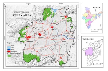
Water is one of the important resources especially in semi-arid tracts and identifying suitable management strategies are highly tactical. The present study is an attempt to suggest suitable management techniques for the study area viz., the Kongu Uplands. The Uplands is an extension of Deccan Plateau in Tamil Nadu which consists of 81 blocks and distributed over 8 districts in which it covers 25,000 sq km of geographical area. Overlay method with the help of Geographical Information System (GIS) has been adopted in the study. The eight parameters such as are land use/ land cover, cropping intensity, population density, water level fluctuation, groundwater potential and rainfall have been adopted and analysed. The overall result in general reveals that most parts of the Upland areas need to adopt moderate level of management strategies.

Keywords: Management; GIS; Overlay Method; Water Level Fluctuation; Groundwater Level; Cropping Intensity

References

  1. Kumar R, Singh RD, Sharma KD. Water Resources of India. Current science. 2005;2(5):794–811.
  2. Chinnasamy P, Agoramoorthy G. Groundwater Storage and Depletion Trends in Tamil Nadu State, India. Water Resources Management. 2015;29(7):2139–2152. Available from: https://dx.doi.org/10.1007/s11269-015-0932-z
  3. Kumaraswamy K, NJR. Spatio-temporal Analysis of Landuse/ Land Cover Analysis of Kolli Hills Environment. Tamil Nadu, Geographic Analysis. 2015;4(2):34–40.
  4. Anuradha CT, Prabhavathy S. Water Resources Management for Virudhunagar District Using Remote Sensing and GIS. International Journal of Earth Sciences and Engineering. 2010;3(1):55–61.
  5. Balasubramani K, Murthy KR, Gomathi M, Kumaraswamy K. Integrated assessment of groundwater resources in a semi-arid watershed of South India: implications for irrigated agriculture. GeoJournal. 2020;85(6):1701–1723. Available from: https://dx.doi.org/10.1007/s10708-019-10050-0
  6. Kumaraswamy K, Sundararaj P, Murthy K, Muruganadam R, Balachandar D. Landuse/ Land Cover Mapping of Pambar Basin, Central Tamil Nadu Using Remote Sensing Data. International Journal of Natural Sciences. 2011;1(4):225–232.
  7. Kumaraswamy K, Sivagnanam N. Regional Resources Appraisal through Factor Analysis Technique - A Case Study on the Countries of Monsoon Asia. Indian Journal of Regional Science. 1988;20(1):39–44.
  8. Shahid S. Rainfall variability and the trends of wet and dry periods in Bangladesh. International Journal of Climatology. 2010;30(15):2299–2313. Available from: https://dx.doi.org/10.1002/joc.2053
  9. Anand B, Karunanidhi D, Subramani T, Srinivasamoorthy K, Suresh M. Long-term trend detection and spatiotemporal analysis of groundwater levels using GIS techniques in Lower Bhavani River basin, Tamil Nadu, India. Environment, Development and Sustainability. 2020;22(4):2779–2800. Available from: https://dx.doi.org/10.1007/s10668-019-00318-3
  10. Sharma MP, Kujur A. Application of Remote Sensing and GIS for Groundwater Recharge Zone in and around Gola Block, Ramgargh District. International Journal of Scientific and Research Publications. 2012;2(2):1–5.

Copyright

© 2019 Priyanka & Kumaraswamy.  This is an open-access article distributed under the terms of the Creative Commons Attribution License, which permits unrestricted use, distribution, and reproduction in any medium, provided the original author and source are credited.

Published By Bangalore University, Bengaluru, Karnataka

DON'T MISS OUT!

Subscribe now for latest articles and news.