Geo-Eye
Department of Geography & GIS
Department of Geography & GIS
Geo-Eye
DOI: 10.53989/bu.ge.v15.i1.26.10
Year: 2026, Volume: 15, Issue: 1, Pages: 23-31
Original Article
Aparna 1*, Ashok D Hanjagi2
1Research Scholar, Department of Geography, Bangalore University, Bengaluru – 560056, Karnataka, India.
2Senior Professor, Department of Geography, Bangalore University, Bengaluru – 560056, Karnataka, India.
*Corresponding author
Email: [email protected]
Received Date:27 July 2026, Accepted Date:07 August 2026
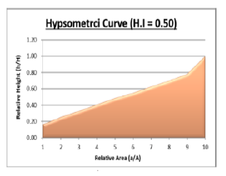
Morphometric analysis of river basins provides vital quantitative information for understanding watershed characteristics, hydrological behaviour, and geomorphic evolution, which are essential for sustainable water and land resource management. The present study evaluates the morphometric and hypsometric characteristics of the Karanja River Basin, a right-bank tributary of the Godavari River in peninsular India, using remote sensing and GIS techniques. ALOS PALSAR DEM data with 12.5 m spatial resolution were employed to delineate the basin and extract linear, areal, and relief morphometric parameters following standard methods proposed by Horton, Strahler, and Schumm. The basin covers an area of 2953.03 km² and exhibits a well-developed seventh-order drainage network. The mean bifurcation ratio (4.31) indicates minimal structural disturbance, while drainage density (2.05 km/km²) and stream frequency (2.57 km⁻²) suggest moderate runoff and infiltration capacity. Areal parameters, including circulatory ratio (0.22), elongation ratio (0.49), and form factor (0.19), reveal elongated basin geometry, favourable for reduced peak discharge and enhanced flood regulation. Hypsometric analysis yielded a hypsometric integral value of 0.50, indicating that the basin is in a mature or equilibrium geomorphic stage with moderate erosion and active denudational processes. Overall, the results highlight a moderately dissected and evolving landscape, providing valuable insights for watershed prioritization, erosion control, and sustainable river basin management.
Keywords: Morphometric analysis, Hypsometric curve, Remote Sensing & GIS, Karanja River Basin
1. Strahler AN. (1954). Quantitative geomorphology of erosional landscapes. In CR 19th International Geological Congress, Algiers, 1952 (pp. 341-354).
2. Central Ground Water Board. Ground water information booklet, Bidar district, Karnataka. South Western Region, Bangalore. 2012; Available from: https://cgwb.gov.in/old_website/District_Profile/karnataka/2012/BIDAR_brochure%202012.pdf
3. Gautam PK. Drainage analysis of the Karanja River basin, Karnataka, India using Geo-informatics. Applied Geomatics. 2024; 16 (4). Available from: https://doi.org/10.1007/s12518-024-00584-5
4. Horton RE. Drainage‐basin characteristics. Eos, Transactions American Geophysical Union. 1932; 13 (1). Available from: https://doi.org/10.1029/tr013i001p00350
5. Horton RE. Erosional development of streams and their drainage basins; hydrophysical approach to quantitative morphology. Geological Society of America Bulletin. 1945; 56 (3). Available from: https://doi.org/10.1130/0016-7606(1945)56[275:edosat]2.0.co;2
6. Irfan S, Hanjagi AD. Evaluation Of Carto Sat Dem-Derived Morphometric Parameters - A Case Study On Arkavathi Watershed Of Karnataka, India. Geo Eye. 2020; 9 (1). Available from: https://doi.org/10.53989/bu.ge.v9i1.10
7. Javed A, Khanday MY, Ahmed R. Prioritization of sub-watersheds based on morphometric and land use analysis using remote sensing and GIS techniques. Journal of the Indian Society of Remote Sensing. 2009; 37 (2). Available from: https://doi.org/10.1007/s12524-009-0016-8
8. Kumar P, Vishwanath BC, Hanjagi AD, Mahalingam B, Singh Rathore M. Geomorphological Assessment of the Barakar River Basin: A Hypsometric and Morphometric Approach Using GIS. Geographical Analysis. 2024; 13 (2). Available from: https://doi.org/10.53989/bu.ga.v13i2.208
9. Manjunatha S, Dalwai M, Sukhaye R, Davithuraj J. Morphometric Analysis of Karanja River Basin, Bidar District, Karnataka, India, using Remote Sensing and GIS Techniques. Journal of Geosciences Research. 2017; 2 (1). Available from: https://www.gondwanags.org.in/wp-content/uploads/2021/11/6-JGSR-Vol-2-1-LR-Abstracts-Manjunatha-et-al.pdf
10. Melton MA. An analysis of the relations among elements of climate, surface properties, and geomorphology (No. CUTR11). 1957; Available from: https://doi.org/10.21236/ad0148373
11. Miller VC. (1953). A quantitative geomorphic study of drainage basin characteristics in the Clinch Mountain area, Virginia and Tennessee. Columbia University
12. Pike RJ, Wilson SE. Elevation-Relief Ratio, Hypsometric Integral, and Geomorphic Area-Altitude Analysis. Geological Society of America Bulletin. 1971; 82 (4). Available from: https://doi.org/10.1130/0016-7606(1971)82[1079:erhiag]2.0.co;2
13. Prakash K, Rawat D, Singh S, Chaubey K, Kanhaiya S, Mohanty T. Morphometric analysis using SRTM and GIS in synergy with depiction: a case study of the Karmanasa River basin, North central India. Applied Water Science. 2019; 9 (1). Available from: https://doi.org/10.1007/s13201-018-0887-3
14. Sarp G, Duzgun S, Toprak V. Hypsometric properties of the hydrolic basins located on western part of NAFZ. 34th International Symposium on Remote Sensing of Environment, The GEOSS Era: Towards Operational Environmental Monitoring, Sydney, Australia. 2011, April; Available from: https://www.isprs.org/proceedings/2011/isrse-34/211104015Final00591.pdf
15. Schumm SA. Evolution of drainage systems and slopes in badlands at Perth Amboy, New Jersey. Geological Society of America Bulletin. 1956; 67 (5). Available from: https://doi.org/10.1130/0016-7606(1956)67[597:eodsas]2.0.co;2
16. Sharma SK, Gajbhiye S, Tignath S, Patil RJ. Hypsometric Analysis for Assessing Erosion Status of Watershed Using Geographical Information System. Water Science and Technology Library. 2018; Available from: https://doi.org/10.1007/978-981-10-5801-1_19
17. Sheik Mohideen AR. Morphometric assessment of hydrogeomorphic processes and landscape evolution in the Kallar watershed (Western Ghats, India): regionalisation and prioritisation. Arabian Journal of Geosciences. 2021; 14 (18). Available from: https://doi.org/10.1007/s12517-021-08105-z
18. Shekar PR, Mathew A. Evaluation of Morphometric and Hypsometric Analysis of the Bagh River Basin using Remote Sensing and Geographic Information System Techniques. Energy Nexus. 2022; 7 Available from: https://doi.org/10.1016/j.nexus.2022.100104
19. Shekar PR, Mathew A, Abdo HG, Almohamad H, Abdullah Al Dughairi A, Al-Mutiry M. Prioritizing sub-watersheds for soil erosion using geospatial techniques based on morphometric and hypsometric analysis: a case study of the Indian Wyra River basin. Applied Water Science. 2023; 13 (7). Available from: https://doi.org/10.1007/s13201-023-01963-w
20. Singh T. Hypsometric analysis of watersheds developed on actively deforming Mohand anticlinal ridge, NW Himalaya. Geocarto International. 2008; 23 (6). Available from: https://doi.org/10.1080/10106040801965821
21. Smith KG. Standards for grading texture of erosional topography. American Journal of Science. 1950; 248 (9). Available from: https://doi.org/10.2475/ajs.248.9.655
22. Strahler AN (1964) Quantitative geomorphology of drainage basins and channel networks. In: Chow VT (ed) Handbook of applied hydrology. McGraw Hill Book Company, New York, pp 4-11
23. Strahler AN. Hypsometric (area-altitude) analysis of erosional topography. Geological Society of America Bulletin. 1952; 63 (11). Available from: https://doi.org/10.1130/0016-7606(1952)63[1117:haaoet]2.0.co;2
24. Waikar ML, Nilawar AP. Morphometric analysis of a drainage basin using geographical information system: a case study. International Journal of Multidisciplinary and Current Research. 2014; 2 (1). Available from: https://ijmcr.com/index.php/ijmcr/article/view/02.01.32
25. Willgoose G, Hancock G. Revisiting the hypsometric curve as an indicator of form and process in transport-limited catchment. Earth Surface Processes and Landforms. 1998; 23 (7). Available from: https://doi.org/10.1002/(sici)1096-9837(199807)23:7<611::aid-esp872>3.0.co;2-y
26. Yadav SK, Singh SK, Gupta M, Srivastava PK. Morphometric analysis of Upper Tons basin from Northern Foreland of Peninsular India using CARTOSAT satellite and GIS. Geocarto International. 2014; 29 (8). Available from: https://doi.org/10.1080/10106049.2013.868043
© 2026 Aparna & Hanjagi. This is an open-access article distributed under the terms of the Creative Commons Attribution License, which permits unrestricted use, distribution, and reproduction in any medium, provided the original author and source are credited.
Published By Bangalore University, Bengaluru, Karnataka
Subscribe now for latest articles and news.