Geo-Eye

Department of Geography & GIS

Article

Geo-Eye

Year: 2025, Volume: 14, Issue: 1, Pages: 47-53

Original Article

Monitoring Rice Crop Dynamics in Koppal District using Time-Series Sentinel-1 Data on Google Earth Engine

Received Date:12 March 2025, Accepted Date:20 June 2025

Abstract

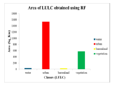
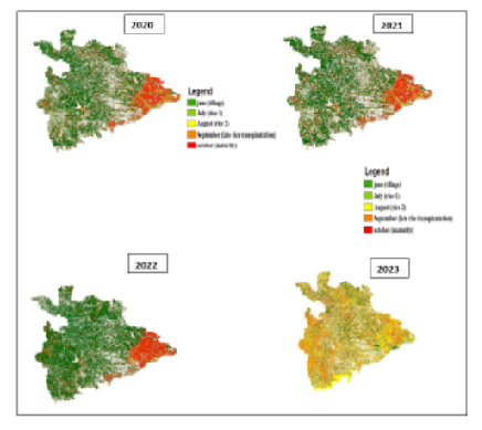
Accurate estimation of crop area and timely assessment of crop losses are essential for empowering farmers, especially as technological advancements transform methods of area estimation, crop production, and crop insurance. This study focuses on mapping rice crop dynamics during the Kharif season (June to October) using satellite-based time-series data. We employed data from Sentinel-1 and Sentinel-2 satellites, combined with the Random Forest classification technique, to identify late transplantation and monitor rice growth at 15-day intervals. The study analyzed data from 2019 to 2023 and classified six crop categories using a robust sampling method. The methodology demonstrated high classification accuracy, ranging from 84.53% to 91.23% across different datasets and phases of crop growth. Results show that the total rice crop area in Koppal district fluctuated moderately between 2020 and 2023, ranging from 53,121.36 ha to 59,129.33 ha, indicating overall stability in rice cultivation despite seasonal variations and the effectiveness of spatiotemporal analysis for yield estimation, risk forecasting, and agricultural planning. This approach can contribute significantly to the development of sustainable agricultural strategies and policies, especially in densely populated countries like India.

Keywords: Crop mapping, Satellite remote sensing, Random Forest, Rice monitoring, Climate risk, Agricultural planning

References

  1. Job MK, Nandamohan M. Growth of Rice in Kerala: An Economic Analysis. 2004.
  2. Zhang M, Li H, Liu L, Deng C, Li C. Annual maps of paddy rice planting areas in China and India from 2000 to 2015. Scientific Data. 2017;4:170068.
  3. Shew AM, Ghosh A. Mapping rice cultivation with Sentinel-1 SAR time series data: A case study in India. Remote Sensing Applications: Society and Environment. 2019;13:148–158.
  4. Shapla SR, Rahman MM, Al-Amin M. Rice area mapping using MODIS time series data in Bangladesh. Journal of Geomatics, Planning and Development. 2015;3(2):1–8.
  5. Singha M, Islam MA, Rahman MM. Rice area mapping using Sentinel-1 SAR and Sentinel-2 optical data in Bangladesh. International Journal of Remote Sensing. 2019;40(10):3907–3929.
  6. Tiwari V, Singh K, Roy C. Rice crop mapping using Sentinel-1 and Sentinel-2 data in Eastern India. Journal of the Indian Society of Remote Sensing. 2021;49(10):2235–2247.
  7. Gumma MK. Rice area mapping using MODIS time series data for Asia. Journal of Environmental Science and Engineering (JESE). 2011;53(3):329–336.
  8. Islam MA. Paddy rice mapping using Google Earth Engine and Sentinel-1 data in Bangladesh. Journal of Geoinformatics and Remote Sensing. 2021;8(1):1–10.
  9. Pena-Arancibia JI, Phongsai S, Bador M. Rice crop mapping in Southeast Asia using Sentinel-1 SAR time series data. Remote Sensing. 2021;13(22):4642.
  10. Shamsuzzoha M, Islam MS, Rahman MM. Rice crop mapping using Sentinel-1 SAR time series data in Bangladesh. Geocarto International. 2022;37(10):3297–3315.
  11. Islam MA, Rahman MM, Hossain MA. Rice crop mapping using Sentinel-1 SAR time series data in Bangladesh. Geocarto International. 2022;37(10):3297–3315.
  12. Mahboob MN, Hassan MQ, Hoque MA. Mapping of rice areas in Bangladesh using MODIS time series data. Journal of Agricultural and Environmental Sciences. 2016;11(1):1–8.
  13. Alam MM, Rashid MH, Zaman MM, Rahman MA. Mapping Boro rice area using MODIS satellite imagery and field data in Bangladesh. Journal of Environmental Science and Natural Resources. 2019;12(1):167–176.
  14. Aziz AB, Rahman A, Alam MS. Rice crop mapping using Sentinel-1 SAR time series data in Bangladesh. Journal of Remote Sensing Applications. 2023;3(1):1–10.
  15. Kamal MA, Islam MS, Akter S. Rice crop mapping using Sentinel-1 and Sentinel-2 time-series data and machine learning algorithms. Remote Sensing Applications: Society and Environment. 2020;19:100350.
  16. Xiao X, Boles S, Liu J, Zhuang D, Frolking S, Li C, et al. Mapping paddy rice agriculture in southern China using multi-temporal MODIS images. Remote Sensing of Environment. 2005;95(4):480–492.
  17. Jiang X, Zhang M, Wang Y. Rice mapping in subtropical regions using Sentinel-1 SAR and Sentinel-2 optical data. Remote Sensing. 2023;15(2):488.
  18. Gumma MK, Mohammed IA, Mude J. Remote sensing for rice area mapping and yield estimation in Bangladesh. Journal of Land Use Science. 2014;9(3):346–361.
  19. More SK, Manjunath KR. Rice crop acreage estimation using MODIS satellite data. International Journal of Advanced Remote Sensing and GIS. 2013;2(1):1–8.
  20. Nelson A, Gumma MK, Velde Mvd. Knowledge-based classification for mapping paddy rice areas. Remote Sensing. 2014;6(1):74–98.
  21. Umesh B, et al. Changing cropping patterns in Gangavathi Taluk of Koppal District. International Journal of Current Microbiology and Applied Sciences. 2021;10(1):2288–2296.

Copyright

© 2025 Naik et al. This is an open-access article distributed under the terms of the Creative Commons Attribution License, which permits unrestricted use, distribution, and reproduction in any medium, provided the original author and source are credited.

Published By Bangalore University, Bengaluru, Karnataka

DON'T MISS OUT!

Subscribe now for latest articles and news.